UT53 Utah53 - Earthquake Result Viewer
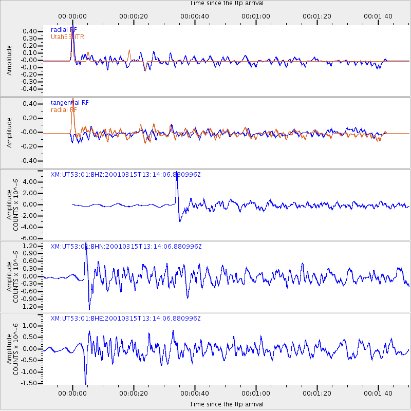
Earthquake location: Near Coast Of Central Chile
Earthquake latitude/longitude: -32.3/-71.5
Earthquake time(UTC): 2001/03/15 (074) 13:02:42 GMT
Earthquake Depth: 37 km
Earthquake Magnitude: 6.1 MB, 5.6 MS, 6.0 MW, 5.4 MD
Earthquake Catalog/Contributor: WHDF/NEIC
Network: XM Rio Grande Seismic Transect
Station: UT53 Utah53
Lat/Lon: 37.35 N/110.33 W
Elevation: 1291 m
Distance: 78.2 deg
Az: 329.3 deg
Baz: 147.152 deg
Ray Param: 0.049734797
Estimated Moho Depth: 31.5 km
Estimated Crust Vp/Vs: 1.81
Assumed Crust Vp: 6.247 km/s
Estimated Crust Vs: 3.446 km/s
Estimated Crust Poisson's Ratio: 0.28
Radial Match: 85.31873 %
Radial Bump: 400
Transverse Match: 74.19829 %
Transverse Bump: 400
SOD ConfigId: 4714
Insert Time: 2010-02-26 17:29:18.077 +0000
GWidth: 2.5
Max Bumps: 400
Tol: 0.001

Signal To Noise

ChannelStoNSTALTA
XM:UT53:01:BHN:20010315T13:14:06.880996Z7.1075554.2358164E-75.9595973E-8
XM:UT53:01:BHE:20010315T13:14:06.880996Z3.23296024.5656523E-71.4122203E-7
XM:UT53:01:BHZ:20010315T13:14:06.880996Z11.3602581.6803568E-61.4791537E-7
Arrivals
Ps4.2 SECOND
PpPs14 SECOND
PsPs/PpSs18 SECOND