You are here: Home > Network List > TX - Texas Seismological Network Stations List
> Station FW06 Azle > Earthquake Result Viewer
FW06 Azle - Earthquake Result Viewer
| Earthquake location: |
Northern Alaska |
| Earthquake latitude/longitude: |
69.5/-144.4 |
| Earthquake time(UTC): |
2018/08/12 (224) 21:15:01 GMT |
| Earthquake Depth: |
1.7 km |
| Earthquake Magnitude: |
6.0 Mww |
| Earthquake Catalog/Contributor: |
NEIC PDE/ak |
|
| Network: |
TX Texas Seismological Network |
| Station: |
FW06 Azle |
| Lat/Lon: |
32.97 N/97.56 W |
| Elevation: |
233 m |
|
| Distance: |
44.8 deg |
| Az: |
119.588 deg |
| Baz: |
338.649 deg |
| Ray Param: |
0.07171195 |
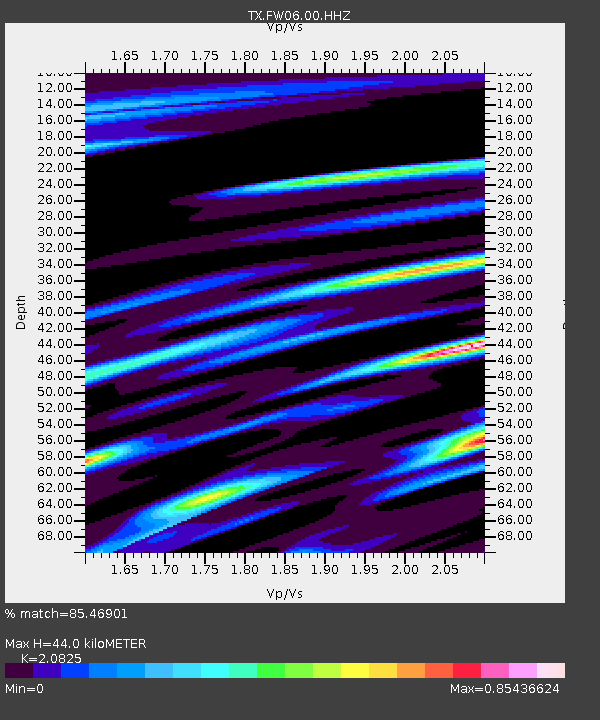
| Estimated Moho Depth: |
44.0 km |
| Estimated Crust Vp/Vs: |
2.08 |
| Assumed Crust Vp: |
6.38 km/s |
| Estimated Crust Vs: |
3.064 km/s |
| Estimated Crust Poisson's Ratio: |
0.35 |
|
| Radial Match: |
85.46901 % |
| Radial Bump: |
266 |
| Transverse Match: |
59.948837 % |
| Transverse Bump: |
400 |
| SOD ConfigId: |
2825771 |
| Insert Time: |
2018-08-26 21:27:41.778 +0000 |
| GWidth: |
2.5 |
| Max Bumps: |
400 |
| Tol: |
0.001 |
|

Signal To Noise
| Channel | StoN | STA | LTA |
| TX:FW06:00:HHZ:20180812T21:22:46.140011Z | 14.271495 | 9.100462E-7 | 6.3766706E-8 |
| TX:FW06:00:HH1:20180812T21:22:46.140011Z | 3.1732683 | 3.2328907E-7 | 1.0187889E-7 |
| TX:FW06:00:HH2:20180812T21:22:46.140011Z | 1.6750124 | 1.403469E-7 | 8.378857E-8 |
| Arrivals |
| Ps | 7.9 SECOND |
| PpPs | 20 SECOND |
| PsPs/PpSs | 28 SECOND |


