You are here: Home > Network List > XM99 - Rio Grande Seismic Transect Stations List
> Station UT53 Utah53 > Earthquake Result Viewer
UT53 Utah53 - Earthquake Result Viewer
*The percent match for this event was below the threshold and hence no stack was calculated.
| Earthquake location: |
El Salvador |
| Earthquake latitude/longitude: |
13.3/-88.8 |
| Earthquake time(UTC): |
2001/02/28 (059) 18:50:13 GMT |
| Earthquake Depth: |
65 km |
| Earthquake Magnitude: |
5.3 MB, 6.1 MW, 5.6 MD |
| Earthquake Catalog/Contributor: |
WHDF/NEIC |
|
| Network: |
XM Rio Grande Seismic Transect |
| Station: |
UT53 Utah53 |
| Lat/Lon: |
37.35 N/110.33 W |
| Elevation: |
1291 m |
|
| Distance: |
30.7 deg |
| Az: |
325.103 deg |
| Baz: |
135.661 deg |
| Ray Param: |
$rayparam |
*The percent match for this event was below the threshold and hence was not used in the summary stack. |
|
| Radial Match: |
97.825455 % |
| Radial Bump: |
373 |
| Transverse Match: |
89.84907 % |
| Transverse Bump: |
400 |
| SOD ConfigId: |
3744 |
| Insert Time: |
2010-02-26 17:29:22.850 +0000 |
| GWidth: |
2.5 |
| Max Bumps: |
400 |
| Tol: |
0.001 |
|
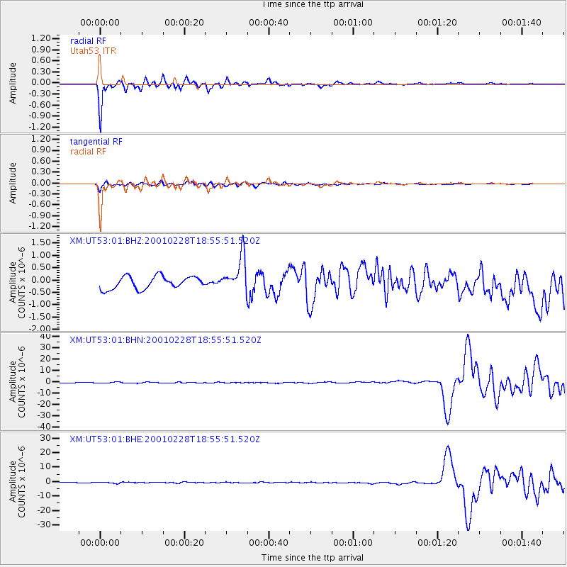
Signal To Noise
| Channel | StoN | STA | LTA |
| XM:UT53:01:BHN:20010228T18:55:51.520Z | 1.9506956 | 5.301357E-7 | 2.717675E-7 |
| XM:UT53:01:BHE:20010228T18:55:51.520Z | 2.596859 | 4.7926983E-7 | 1.845575E-7 |
| XM:UT53:01:BHZ:20010228T18:55:51.520Z | 2.9243662 | 7.4463276E-7 | 2.546305E-7 |
| Arrivals |
| Ps | |
| PpPs | |
| PsPs/PpSs | |


