You are here: Home > Network List > TX - Texas Seismological Network Stations List
> Station SN06 Snyder 6 > Earthquake Result Viewer
SN06 Snyder 6 - Earthquake Result Viewer
| Earthquake location: |
Northern Alaska |
| Earthquake latitude/longitude: |
69.5/-144.4 |
| Earthquake time(UTC): |
2018/08/12 (224) 21:15:01 GMT |
| Earthquake Depth: |
1.7 km |
| Earthquake Magnitude: |
6.0 Mww |
| Earthquake Catalog/Contributor: |
NEIC PDE/ak |
|
| Network: |
TX Texas Seismological Network |
| Station: |
SN06 Snyder 6 |
| Lat/Lon: |
32.88 N/100.93 W |
| Elevation: |
769 m |
|
| Distance: |
43.9 deg |
| Az: |
123.432 deg |
| Baz: |
339.572 deg |
| Ray Param: |
0.07228705 |
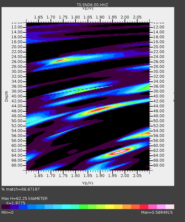
| Estimated Moho Depth: |
62.25 km |
| Estimated Crust Vp/Vs: |
1.98 |
| Assumed Crust Vp: |
6.426 km/s |
| Estimated Crust Vs: |
3.25 km/s |
| Estimated Crust Poisson's Ratio: |
0.33 |
|
| Radial Match: |
86.67197 % |
| Radial Bump: |
230 |
| Transverse Match: |
52.976833 % |
| Transverse Bump: |
400 |
| SOD ConfigId: |
2825771 |
| Insert Time: |
2018-08-26 21:28:19.286 +0000 |
| GWidth: |
2.5 |
| Max Bumps: |
400 |
| Tol: |
0.001 |
|
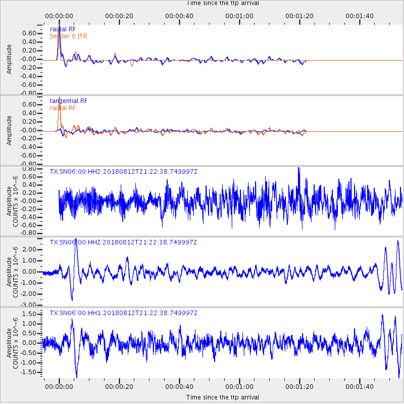
Signal To Noise
| Channel | StoN | STA | LTA |
| TX:SN06:00:HHZ:20180812T21:22:38.749997Z | 7.599326 | 8.474775E-7 | 1.11520094E-7 |
| TX:SN06:00:HH1:20180812T21:22:38.749997Z | 2.7469907 | 4.4796147E-7 | 1.6307352E-7 |
| TX:SN06:00:HH2:20180812T21:22:38.749997Z | 1.0829498 | 1.7966869E-7 | 1.6590676E-7 |
| Arrivals |
| Ps | 10 SECOND |
| PpPs | 27 SECOND |
| PsPs/PpSs | 37 SECOND |


