You are here: Home > Network List > TX - Texas Seismological Network Stations List
> Station MNHN Monahans > Earthquake Result Viewer
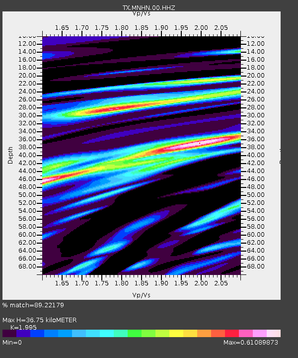
MNHN Monahans - Earthquake Result Viewer
| Earthquake location: |
Northern Alaska |
| Earthquake latitude/longitude: |
69.5/-144.4 |
| Earthquake time(UTC): |
2018/08/12 (224) 21:15:01 GMT |
| Earthquake Depth: |
1.7 km |
| Earthquake Magnitude: |
6.0 Mww |
| Earthquake Catalog/Contributor: |
NEIC PDE/ak |
|
| Network: |
TX Texas Seismological Network |
| Station: |
MNHN Monahans |
| Lat/Lon: |
31.34 N/102.76 W |
| Elevation: |
750 m |
|
| Distance: |
44.8 deg |
| Az: |
126.266 deg |
| Baz: |
340.632 deg |
| Ray Param: |
0.071718775 |
| Estimated Moho Depth: |
36.75 km |
| Estimated Crust Vp/Vs: |
2.00 |
| Assumed Crust Vp: |
6.121 km/s |
| Estimated Crust Vs: |
3.068 km/s |
| Estimated Crust Poisson's Ratio: |
0.33 |
|
| Radial Match: |
89.22179 % |
| Radial Bump: |
340 |
| Transverse Match: |
74.1856 % |
| Transverse Bump: |
400 |
| SOD ConfigId: |
2825771 |
| Insert Time: |
2018-08-26 21:28:30.350 +0000 |
| GWidth: |
2.5 |
| Max Bumps: |
400 |
| Tol: |
0.001 |
|

Signal To Noise
| Channel | StoN | STA | LTA |
| TX:MNHN:00:HHZ:20180812T21:22:46.04501Z | 9.78982 | 8.446355E-7 | 8.627692E-8 |
| TX:MNHN:00:HH1:20180812T21:22:46.04501Z | 2.439823 | 1.3450129E-7 | 5.5127483E-8 |
| TX:MNHN:00:HH2:20180812T21:22:46.04501Z | 7.883689 | 5.1429697E-7 | 6.5235575E-8 |
| Arrivals |
| Ps | 6.3 SECOND |
| PpPs | 17 SECOND |
| PsPs/PpSs | 23 SECOND |


