You are here: Home > Network List > N4 - Central and EAstern US Network Stations List
> Station V53A Sandy Mush, NC, USA > Earthquake Result Viewer
V53A Sandy Mush, NC, USA - Earthquake Result Viewer
| Earthquake location: |
Off Coast Of Oregon |
| Earthquake latitude/longitude: |
44.5/-130.2 |
| Earthquake time(UTC): |
2022/06/15 (166) 11:56:32 GMT |
| Earthquake Depth: |
10 km |
| Earthquake Magnitude: |
5.6 Mww |
| Earthquake Catalog/Contributor: |
NEIC PDE/us |
|
| Network: |
N4 Central and EAstern US Network |
| Station: |
V53A Sandy Mush, NC, USA |
| Lat/Lon: |
35.67 N/82.81 W |
| Elevation: |
681 m |
|
| Distance: |
36.9 deg |
| Az: |
87.058 deg |
| Baz: |
298.589 deg |
| Ray Param: |
0.07646642 |
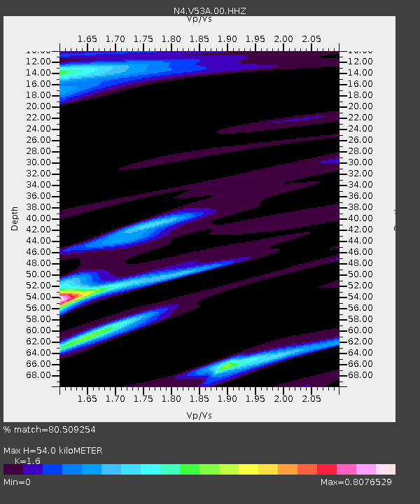
| Estimated Moho Depth: |
54.0 km |
| Estimated Crust Vp/Vs: |
1.60 |
| Assumed Crust Vp: |
6.35 km/s |
| Estimated Crust Vs: |
3.969 km/s |
| Estimated Crust Poisson's Ratio: |
0.18 |
|
| Radial Match: |
80.509254 % |
| Radial Bump: |
361 |
| Transverse Match: |
61.731934 % |
| Transverse Bump: |
400 |
| SOD ConfigId: |
28208852 |
| Insert Time: |
2022-06-29 12:04:37.365 +0000 |
| GWidth: |
2.5 |
| Max Bumps: |
400 |
| Tol: |
0.001 |
|

Signal To Noise
| Channel | StoN | STA | LTA |
| N4:V53A:00:HHZ:20220615T12:03:10.408989Z | 2.0827658 | 2.1260485E-7 | 1.0207813E-7 |
| N4:V53A:00:HH1:20220615T12:03:10.408989Z | 0.877842 | 9.2443734E-8 | 1.0530794E-7 |
| N4:V53A:00:HH2:20220615T12:03:10.408989Z | 1.2036018 | 8.048559E-8 | 6.687061E-8 |
| Arrivals |
| Ps | 5.5 SECOND |
| PpPs | 20 SECOND |
| PsPs/PpSs | 26 SECOND |


