You are here: Home > Network List > TX - Texas Seismological Network Stations List
> Station PB11 Snyder 1 > Earthquake Result Viewer
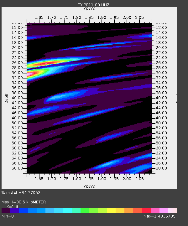
PB11 Snyder 1 - Earthquake Result Viewer
| Earthquake location: |
Northern Alaska |
| Earthquake latitude/longitude: |
69.5/-144.4 |
| Earthquake time(UTC): |
2018/08/12 (224) 21:15:01 GMT |
| Earthquake Depth: |
1.7 km |
| Earthquake Magnitude: |
6.0 Mww |
| Earthquake Catalog/Contributor: |
NEIC PDE/ak |
|
| Network: |
TX Texas Seismological Network |
| Station: |
PB11 Snyder 1 |
| Lat/Lon: |
31.94 N/104.03 W |
| Elevation: |
915 m |
|
| Distance: |
43.9 deg |
| Az: |
127.452 deg |
| Baz: |
340.816 deg |
| Ray Param: |
0.07229045 |
| Estimated Moho Depth: |
30.5 km |
| Estimated Crust Vp/Vs: |
1.60 |
| Assumed Crust Vp: |
6.361 km/s |
| Estimated Crust Vs: |
3.975 km/s |
| Estimated Crust Poisson's Ratio: |
0.18 |
|
| Radial Match: |
84.77053 % |
| Radial Bump: |
362 |
| Transverse Match: |
59.99268 % |
| Transverse Bump: |
400 |
| SOD ConfigId: |
2825771 |
| Insert Time: |
2018-08-26 21:28:51.076 +0000 |
| GWidth: |
2.5 |
| Max Bumps: |
400 |
| Tol: |
0.001 |
|

Signal To Noise
| Channel | StoN | STA | LTA |
| TX:PB11:00:HHZ:20180812T21:22:38.709988Z | 3.7684252 | 4.5468522E-7 | 1.2065657E-7 |
| TX:PB11:00:HH1:20180812T21:22:38.709988Z | 2.7812464 | 1.3527755E-7 | 4.863918E-8 |
| TX:PB11:00:HH2:20180812T21:22:38.709988Z | 1.1090934 | 7.151264E-8 | 6.4478456E-8 |
| Arrivals |
| Ps | 3.1 SECOND |
| PpPs | 12 SECOND |
| PsPs/PpSs | 15 SECOND |


