You are here: Home > Network List > AZ - ANZA Regional Network Stations List
> Station WMC AZ.WMC > Earthquake Result Viewer
WMC AZ.WMC - Earthquake Result Viewer
| Earthquake location: |
South Of Fiji Islands |
| Earthquake latitude/longitude: |
-22.1/-176.8 |
| Earthquake time(UTC): |
1997/10/14 (287) 09:53:18 GMT |
| Earthquake Depth: |
167 km |
| Earthquake Magnitude: |
6.7 MB, 7.7 UNKNOWN, 7.4 ME |
| Earthquake Catalog/Contributor: |
WHDF/NEIC |
|
| Network: |
AZ ANZA Regional Network |
| Station: |
WMC AZ.WMC |
| Lat/Lon: |
33.57 N/116.67 W |
| Elevation: |
1271 m |
|
| Distance: |
79.6 deg |
| Az: |
47.372 deg |
| Baz: |
234.815 deg |
| Ray Param: |
0.0484265 |
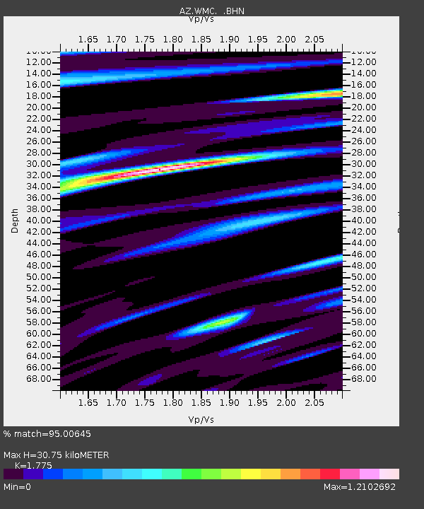
| Estimated Moho Depth: |
30.75 km |
| Estimated Crust Vp/Vs: |
1.77 |
| Assumed Crust Vp: |
6.264 km/s |
| Estimated Crust Vs: |
3.529 km/s |
| Estimated Crust Poisson's Ratio: |
0.27 |
|
| Radial Match: |
95.00645 % |
| Radial Bump: |
400 |
| Transverse Match: |
91.196396 % |
| Transverse Bump: |
400 |
| SOD ConfigId: |
9875 |
| Insert Time: |
2010-03-09 21:13:18.812 +0000 |
| GWidth: |
2.5 |
| Max Bumps: |
400 |
| Tol: |
0.001 |
|

Signal To Noise
| Channel | StoN | STA | LTA |
| AZ:WMC: :BHN:19971014T10:04:35.725Z | 1.507613 | 3.6155382E-7 | 2.3981875E-7 |
| AZ:WMC: :BHE:19971014T10:04:35.725Z | 1.5059384 | 3.1749838E-7 | 2.1083092E-7 |
| AZ:WMC: :BHZ:19971014T10:04:35.725Z | 3.6734197 | 9.0441523E-7 | 2.4620525E-7 |
| Arrivals |
| Ps | 3.9 SECOND |
| PpPs | 13 SECOND |
| PsPs/PpSs | 17 SECOND |


