You are here: Home > Network List > US - United States National Seismic Network Stations List
> Station AMTX Amarillo, Texas, USA > Earthquake Result Viewer
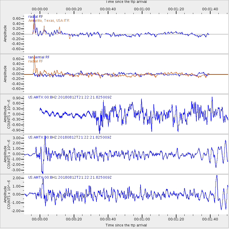
AMTX Amarillo, Texas, USA - Earthquake Result Viewer
*The percent match for this event was below the threshold and hence no stack was calculated.
| Earthquake location: |
Northern Alaska |
| Earthquake latitude/longitude: |
69.5/-144.4 |
| Earthquake time(UTC): |
2018/08/12 (224) 21:15:01 GMT |
| Earthquake Depth: |
1.7 km |
| Earthquake Magnitude: |
6.0 Mww |
| Earthquake Catalog/Contributor: |
NEIC PDE/ak |
|
| Network: |
US United States National Seismic Network |
| Station: |
AMTX Amarillo, Texas, USA |
| Lat/Lon: |
34.53 N/101.41 W |
| Elevation: |
1010 m |
|
| Distance: |
42.2 deg |
| Az: |
123.123 deg |
| Baz: |
339.083 deg |
| Ray Param: |
$rayparam |
*The percent match for this event was below the threshold and hence was not used in the summary stack. |
|
| Radial Match: |
76.1924 % |
| Radial Bump: |
400 |
| Transverse Match: |
51.4096 % |
| Transverse Bump: |
400 |
| SOD ConfigId: |
2825771 |
| Insert Time: |
2018-08-26 21:28:58.313 +0000 |
| GWidth: |
2.5 |
| Max Bumps: |
400 |
| Tol: |
0.001 |
|
Signal To Noise
| Channel | StoN | STA | LTA |
| US:AMTX:00:BHZ:20180812T21:22:21.825009Z | 19.121365 | 1.7881462E-6 | 9.351561E-8 |
| US:AMTX:00:BH1:20180812T21:22:21.825009Z | 8.689558 | 8.119019E-7 | 9.3434195E-8 |
| US:AMTX:00:BH2:20180812T21:22:21.825009Z | 4.8256335 | 4.5749132E-7 | 9.4804406E-8 |
| Arrivals |
| Ps | |
| PpPs | |
| PsPs/PpSs | |


