You are here: Home > Network List > US - United States National Seismic Network Stations List
> Station GLMI Grayling, Michigan, USA > Earthquake Result Viewer
GLMI Grayling, Michigan, USA - Earthquake Result Viewer
| Earthquake location: |
Northern Alaska |
| Earthquake latitude/longitude: |
69.5/-144.4 |
| Earthquake time(UTC): |
2018/08/12 (224) 21:15:01 GMT |
| Earthquake Depth: |
1.7 km |
| Earthquake Magnitude: |
6.0 Mww |
| Earthquake Catalog/Contributor: |
NEIC PDE/ak |
|
| Network: |
US United States National Seismic Network |
| Station: |
GLMI Grayling, Michigan, USA |
| Lat/Lon: |
44.82 N/84.62 W |
| Elevation: |
387 m |
|
| Distance: |
38.4 deg |
| Az: |
98.182 deg |
| Baz: |
330.691 deg |
| Ray Param: |
0.07561071 |
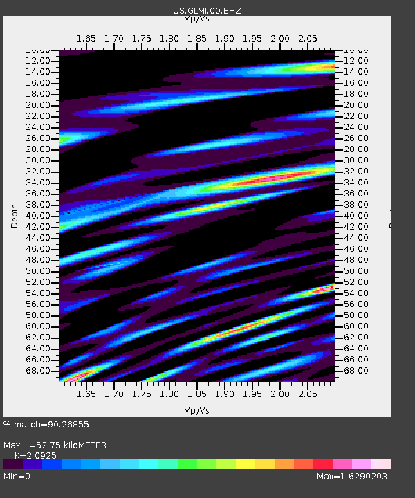
| Estimated Moho Depth: |
52.75 km |
| Estimated Crust Vp/Vs: |
2.09 |
| Assumed Crust Vp: |
6.483 km/s |
| Estimated Crust Vs: |
3.098 km/s |
| Estimated Crust Poisson's Ratio: |
0.35 |
|
| Radial Match: |
90.26855 % |
| Radial Bump: |
400 |
| Transverse Match: |
76.76791 % |
| Transverse Bump: |
400 |
| SOD ConfigId: |
2825771 |
| Insert Time: |
2018-08-26 21:29:21.289 +0000 |
| GWidth: |
2.5 |
| Max Bumps: |
400 |
| Tol: |
0.001 |
|
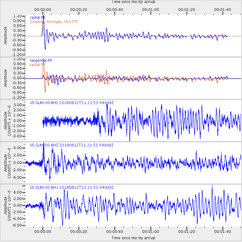
Signal To Noise
| Channel | StoN | STA | LTA |
| US:GLMI:00:BHZ:20180812T21:21:53.64999Z | 5.989753 | 2.1129802E-6 | 3.5276582E-7 |
| US:GLMI:00:BH1:20180812T21:21:53.64999Z | 4.536208 | 1.7119229E-6 | 3.773907E-7 |
| US:GLMI:00:BH2:20180812T21:21:53.64999Z | 2.199302 | 9.863683E-7 | 4.484915E-7 |
| Arrivals |
| Ps | 9.5 SECOND |
| PpPs | 24 SECOND |
| PsPs/PpSs | 33 SECOND |


