You are here: Home > Network List > US - United States National Seismic Network Stations List
> Station VBMS Vicksburg, Mississippi > Earthquake Result Viewer
VBMS Vicksburg, Mississippi - Earthquake Result Viewer
| Earthquake location: |
Northern Alaska |
| Earthquake latitude/longitude: |
69.5/-144.4 |
| Earthquake time(UTC): |
2018/08/12 (224) 21:15:01 GMT |
| Earthquake Depth: |
1.7 km |
| Earthquake Magnitude: |
6.0 Mww |
| Earthquake Catalog/Contributor: |
NEIC PDE/ak |
|
| Network: |
US United States National Seismic Network |
| Station: |
VBMS Vicksburg, Mississippi |
| Lat/Lon: |
32.22 N/90.52 W |
| Elevation: |
16 m |
|
| Distance: |
47.7 deg |
| Az: |
112.35 deg |
| Baz: |
337.417 deg |
| Ray Param: |
0.06982586 |
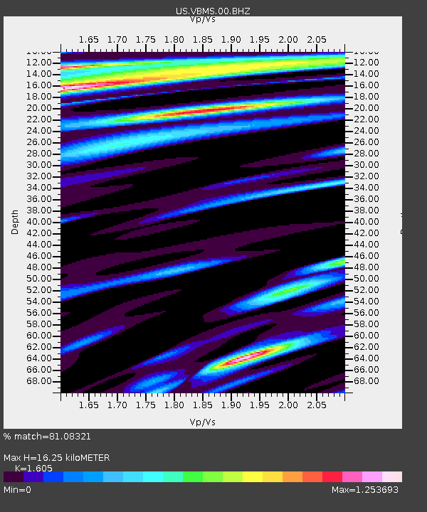
| Estimated Moho Depth: |
16.25 km |
| Estimated Crust Vp/Vs: |
1.61 |
| Assumed Crust Vp: |
6.201 km/s |
| Estimated Crust Vs: |
3.864 km/s |
| Estimated Crust Poisson's Ratio: |
0.18 |
|
| Radial Match: |
81.08321 % |
| Radial Bump: |
400 |
| Transverse Match: |
75.45505 % |
| Transverse Bump: |
400 |
| SOD ConfigId: |
2825771 |
| Insert Time: |
2018-08-26 21:30:03.584 +0000 |
| GWidth: |
2.5 |
| Max Bumps: |
400 |
| Tol: |
0.001 |
|
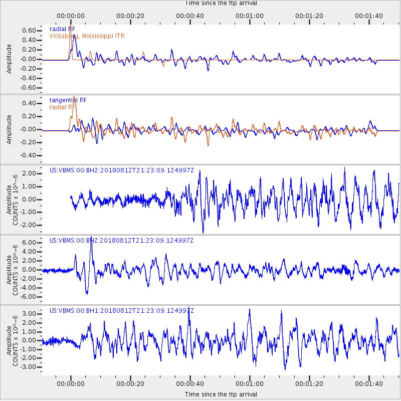
Signal To Noise
| Channel | StoN | STA | LTA |
| US:VBMS:00:BHZ:20180812T21:23:09.124997Z | 6.487241 | 1.2629265E-6 | 1.9467852E-7 |
| US:VBMS:00:BH1:20180812T21:23:09.124997Z | 1.2794112 | 4.0044546E-7 | 3.12992E-7 |
| US:VBMS:00:BH2:20180812T21:23:09.124997Z | 1.320376 | 3.6960574E-7 | 2.7992462E-7 |
| Arrivals |
| Ps | 1.7 SECOND |
| PpPs | 6.4 SECOND |
| PsPs/PpSs | 8.1 SECOND |


