You are here: Home > Network List > AZ - ANZA Regional Network Stations List
> Station WMC AZ.WMC > Earthquake Result Viewer
WMC AZ.WMC - Earthquake Result Viewer
| Earthquake location: |
Jujuy Province, Argentina |
| Earthquake latitude/longitude: |
-23.5/-66.5 |
| Earthquake time(UTC): |
2000/05/12 (133) 18:43:18 GMT |
| Earthquake Depth: |
225 km |
| Earthquake Magnitude: |
6.2 MB, 7.2 MW, 7.1 MW |
| Earthquake Catalog/Contributor: |
WHDF/NEIC |
|
| Network: |
AZ ANZA Regional Network |
| Station: |
WMC AZ.WMC |
| Lat/Lon: |
33.57 N/116.67 W |
| Elevation: |
1271 m |
|
| Distance: |
74.2 deg |
| Az: |
318.188 deg |
| Baz: |
132.876 deg |
| Ray Param: |
0.05185752 |
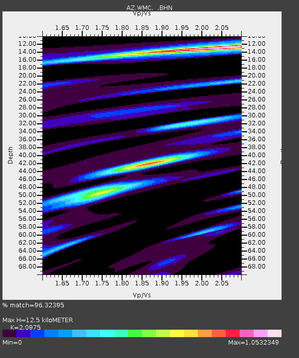
| Estimated Moho Depth: |
12.5 km |
| Estimated Crust Vp/Vs: |
2.10 |
| Assumed Crust Vp: |
6.264 km/s |
| Estimated Crust Vs: |
2.986 km/s |
| Estimated Crust Poisson's Ratio: |
0.35 |
|
| Radial Match: |
96.32395 % |
| Radial Bump: |
400 |
| Transverse Match: |
84.92254 % |
| Transverse Bump: |
400 |
| SOD ConfigId: |
3744 |
| Insert Time: |
2010-03-09 21:16:36.228 +0000 |
| GWidth: |
2.5 |
| Max Bumps: |
400 |
| Tol: |
0.001 |
|

Signal To Noise
| Channel | StoN | STA | LTA |
| AZ:WMC: :BHN:20000512T18:53:59.299016Z | 2.4811647 | 5.388628E-7 | 2.1718141E-7 |
| AZ:WMC: :BHE:20000512T18:53:59.299016Z | 1.9185603 | 4.5216808E-7 | 2.3568093E-7 |
| AZ:WMC: :BHZ:20000512T18:53:59.299016Z | 6.0378947 | 1.3378277E-6 | 2.2157188E-7 |
| Arrivals |
| Ps | 2.2 SECOND |
| PpPs | 6.0 SECOND |
| PsPs/PpSs | 8.3 SECOND |


