You are here: Home > Network List > UW - Pacific Northwest Regional Seismic Network Stations List
> Station UMAT Pilot Rock, OR, USA > Earthquake Result Viewer
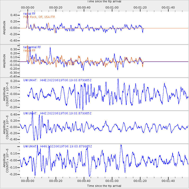
UMAT Pilot Rock, OR, USA - Earthquake Result Viewer
*The percent match for this event was below the threshold and hence no stack was calculated.
| Earthquake location: |
Near West Coast Of Honshu, Japan |
| Earthquake latitude/longitude: |
37.5/137.3 |
| Earthquake time(UTC): |
2022/06/19 (170) 06:08:06 GMT |
| Earthquake Depth: |
10 km |
| Earthquake Magnitude: |
5.1 Mww |
| Earthquake Catalog/Contributor: |
NEIC PDE/us |
|
| Network: |
UW Pacific Northwest Regional Seismic Network |
| Station: |
UMAT Pilot Rock, OR, USA |
| Lat/Lon: |
45.29 N/118.96 W |
| Elevation: |
1318 m |
|
| Distance: |
72.7 deg |
| Az: |
45.902 deg |
| Baz: |
306.005 deg |
| Ray Param: |
$rayparam |
*The percent match for this event was below the threshold and hence was not used in the summary stack. |
|
| Radial Match: |
56.87139 % |
| Radial Bump: |
400 |
| Transverse Match: |
65.95229 % |
| Transverse Bump: |
318 |
| SOD ConfigId: |
28208852 |
| Insert Time: |
2022-07-03 06:37:21.371 +0000 |
| GWidth: |
2.5 |
| Max Bumps: |
400 |
| Tol: |
0.001 |
|
Signal To Noise
| Channel | StoN | STA | LTA |
| UW:UMAT: :HHZ:20220619T06:19:03.879985Z | 3.3073463 | 2.1647031E-7 | 6.545136E-8 |
| UW:UMAT: :HHN:20220619T06:19:03.879985Z | 1.3405414 | 6.0889235E-8 | 4.5421377E-8 |
| UW:UMAT: :HHE:20220619T06:19:03.879985Z | 1.624462 | 8.6317755E-8 | 5.313621E-8 |
| Arrivals |
| Ps | |
| PpPs | |
| PsPs/PpSs | |


