You are here: Home > Network List > AZ - ANZA Regional Network Stations List
> Station WMC AZ.WMC > Earthquake Result Viewer
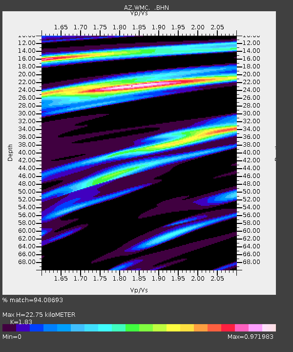
WMC AZ.WMC - Earthquake Result Viewer
| Earthquake location: |
Near Coast Of Guatemala |
| Earthquake latitude/longitude: |
13.6/-90.8 |
| Earthquake time(UTC): |
2003/01/21 (021) 02:46:47 GMT |
| Earthquake Depth: |
24 km |
| Earthquake Magnitude: |
5.5 MB, 6.3 MS, 6.5 MW, 6.3 MW |
| Earthquake Catalog/Contributor: |
WHDF/NEIC |
|
| Network: |
AZ ANZA Regional Network |
| Station: |
WMC AZ.WMC |
| Lat/Lon: |
33.57 N/116.67 W |
| Elevation: |
1271 m |
|
| Distance: |
30.8 deg |
| Az: |
314.576 deg |
| Baz: |
123.953 deg |
| Ray Param: |
0.07922024 |
| Estimated Moho Depth: |
22.75 km |
| Estimated Crust Vp/Vs: |
1.83 |
| Assumed Crust Vp: |
6.264 km/s |
| Estimated Crust Vs: |
3.423 km/s |
| Estimated Crust Poisson's Ratio: |
0.29 |
|
| Radial Match: |
94.08693 % |
| Radial Bump: |
380 |
| Transverse Match: |
82.88337 % |
| Transverse Bump: |
400 |
| SOD ConfigId: |
32974 |
| Insert Time: |
2010-03-09 21:18:05.133 +0000 |
| GWidth: |
2.5 |
| Max Bumps: |
400 |
| Tol: |
0.001 |
|

Signal To Noise
| Channel | StoN | STA | LTA |
| AZ:WMC: :BHN:20030121T02:52:30.92399Z | 1.4826845 | 3.267598E-7 | 2.2038388E-7 |
| AZ:WMC: :BHE:20030121T02:52:30.92399Z | 1.9489468 | 4.541601E-7 | 2.3302847E-7 |
| AZ:WMC: :BHZ:20030121T02:52:30.92399Z | 2.8436623 | 6.542809E-7 | 2.3008387E-7 |
| Arrivals |
| Ps | 3.2 SECOND |
| PpPs | 9.6 SECOND |
| PsPs/PpSs | 13 SECOND |


