You are here: Home > Network List > AZ - ANZA Regional Network Stations List
> Station WMC AZ.WMC > Earthquake Result Viewer
WMC AZ.WMC - Earthquake Result Viewer
| Earthquake location: |
Kuril Islands |
| Earthquake latitude/longitude: |
44.1/148.1 |
| Earthquake time(UTC): |
1995/04/28 (118) 16:30:00 GMT |
| Earthquake Depth: |
29 km |
| Earthquake Magnitude: |
6.6 MB, 6.9 MS, 7.0 UNKNOWN, 6.8 MW |
| Earthquake Catalog/Contributor: |
WHDF/NEIC |
|
| Network: |
AZ ANZA Regional Network |
| Station: |
WMC AZ.WMC |
| Lat/Lon: |
33.57 N/116.67 W |
| Elevation: |
1271 m |
|
| Distance: |
71.0 deg |
| Az: |
61.575 deg |
| Baz: |
310.585 deg |
| Ray Param: |
0.054592866 |
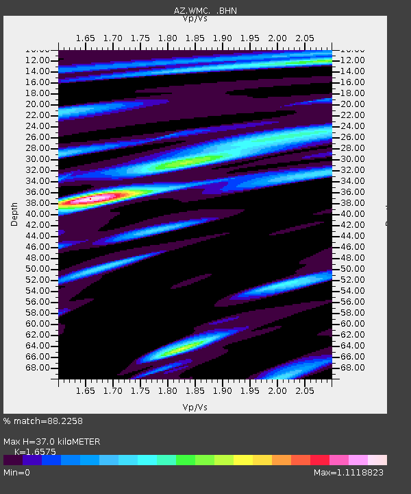
| Estimated Moho Depth: |
37.0 km |
| Estimated Crust Vp/Vs: |
1.66 |
| Assumed Crust Vp: |
6.264 km/s |
| Estimated Crust Vs: |
3.779 km/s |
| Estimated Crust Poisson's Ratio: |
0.21 |
|
| Radial Match: |
88.2258 % |
| Radial Bump: |
400 |
| Transverse Match: |
61.83524 % |
| Transverse Bump: |
400 |
| SOD ConfigId: |
6273 |
| Insert Time: |
2010-03-09 21:19:29.663 +0000 |
| GWidth: |
2.5 |
| Max Bumps: |
400 |
| Tol: |
0.001 |
|

Signal To Noise
| Channel | StoN | STA | LTA |
| AZ:WMC: :BHN:19950428T16:40:44.400012Z | 0.54978037 | 2.098822E-7 | 3.8175642E-7 |
| AZ:WMC: :BHE:19950428T16:40:44.400012Z | 2.5182972 | 5.2719315E-7 | 2.0934509E-7 |
| AZ:WMC: :BHZ:19950428T16:40:44.400012Z | 5.058378 | 1.1019781E-6 | 2.1785206E-7 |
| Arrivals |
| Ps | 4.0 SECOND |
| PpPs | 15 SECOND |
| PsPs/PpSs | 19 SECOND |


