You are here: Home > Network List > AZ - ANZA Regional Network Stations List
> Station WMC AZ.WMC > Earthquake Result Viewer
WMC AZ.WMC - Earthquake Result Viewer
| Earthquake location: |
Colombia |
| Earthquake latitude/longitude: |
5.1/-72.9 |
| Earthquake time(UTC): |
1995/01/19 (019) 15:05:03 GMT |
| Earthquake Depth: |
18 km |
| Earthquake Magnitude: |
6.4 MB, 6.6 MS, 6.5 UNKNOWN, 6.5 MW |
| Earthquake Catalog/Contributor: |
WHDF/NEIC |
|
| Network: |
AZ ANZA Regional Network |
| Station: |
WMC AZ.WMC |
| Lat/Lon: |
33.57 N/116.67 W |
| Elevation: |
1271 m |
|
| Distance: |
49.5 deg |
| Az: |
310.624 deg |
| Baz: |
115.097 deg |
| Ray Param: |
0.06862223 |
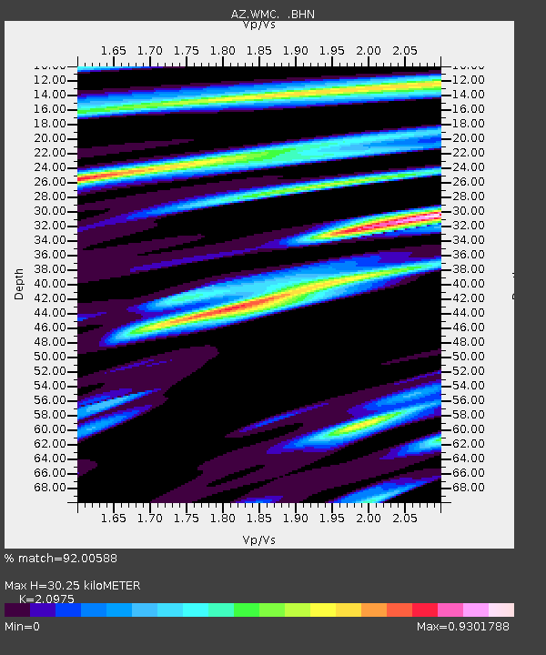
| Estimated Moho Depth: |
30.25 km |
| Estimated Crust Vp/Vs: |
2.10 |
| Assumed Crust Vp: |
6.264 km/s |
| Estimated Crust Vs: |
2.986 km/s |
| Estimated Crust Poisson's Ratio: |
0.35 |
|
| Radial Match: |
92.00588 % |
| Radial Bump: |
400 |
| Transverse Match: |
79.24207 % |
| Transverse Bump: |
400 |
| SOD ConfigId: |
6273 |
| Insert Time: |
2010-03-09 21:19:36.279 +0000 |
| GWidth: |
2.5 |
| Max Bumps: |
400 |
| Tol: |
0.001 |
|

Signal To Noise
| Channel | StoN | STA | LTA |
| AZ:WMC: :BHN:19950119T15:13:22.225Z | 1.5425116 | 4.36343E-7 | 2.8287826E-7 |
| AZ:WMC: :BHE:19950119T15:13:22.225Z | 3.1836786 | 1.2842851E-6 | 4.0339657E-7 |
| AZ:WMC: :BHZ:19950119T15:13:22.225Z | 3.0460124 | 1.5572986E-6 | 5.112581E-7 |
| Arrivals |
| Ps | 5.6 SECOND |
| PpPs | 14 SECOND |
| PsPs/PpSs | 20 SECOND |


