You are here: Home > Network List > GL - Volcanologic Seismologic Observatory Network of Guadeloupe -OVSG Stations List
> Station MML Mamelle > Earthquake Result Viewer
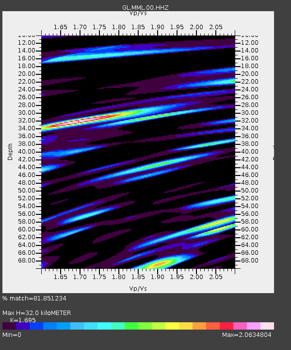
MML Mamelle - Earthquake Result Viewer
| Earthquake location: |
South Sandwich Islands Region |
| Earthquake latitude/longitude: |
-58.1/-25.3 |
| Earthquake time(UTC): |
2018/08/14 (226) 03:29:53 GMT |
| Earthquake Depth: |
35 km |
| Earthquake Magnitude: |
6.1 Mww |
| Earthquake Catalog/Contributor: |
NEIC PDE/us |
|
| Network: |
GL Volcanologic Seismologic Observatory Network of Guadeloupe -OVSG |
| Station: |
MML Mamelle |
| Lat/Lon: |
16.04 N/61.67 W |
| Elevation: |
1197 m |
|
| Distance: |
79.7 deg |
| Az: |
324.55 deg |
| Baz: |
161.325 deg |
| Ray Param: |
0.048699953 |
| Estimated Moho Depth: |
32.0 km |
| Estimated Crust Vp/Vs: |
1.70 |
| Assumed Crust Vp: |
6.048 km/s |
| Estimated Crust Vs: |
3.568 km/s |
| Estimated Crust Poisson's Ratio: |
0.23 |
|
| Radial Match: |
81.851234 % |
| Radial Bump: |
400 |
| Transverse Match: |
75.689964 % |
| Transverse Bump: |
400 |
| SOD ConfigId: |
2825771 |
| Insert Time: |
2018-08-28 03:38:34.189 +0000 |
| GWidth: |
2.5 |
| Max Bumps: |
400 |
| Tol: |
0.001 |
|

Signal To Noise
| Channel | StoN | STA | LTA |
| GL:MML:00:HHZ:20180814T03:41:26.760007Z | 23.37848 | 9.8034525E-6 | 4.1933657E-7 |
| GL:MML:00:HHN:20180814T03:41:26.760007Z | 8.647344 | 6.216034E-6 | 7.1883744E-7 |
| GL:MML:00:HHE:20180814T03:41:26.760007Z | 6.3504357 | 5.8483693E-6 | 9.2093984E-7 |
| Arrivals |
| Ps | 3.8 SECOND |
| PpPs | 14 SECOND |
| PsPs/PpSs | 18 SECOND |


