You are here: Home > Network List > GT - Global Telemetered Seismograph Network (USAF/USGS) Stations List
> Station PLCA Paso Flores, Argentina > Earthquake Result Viewer
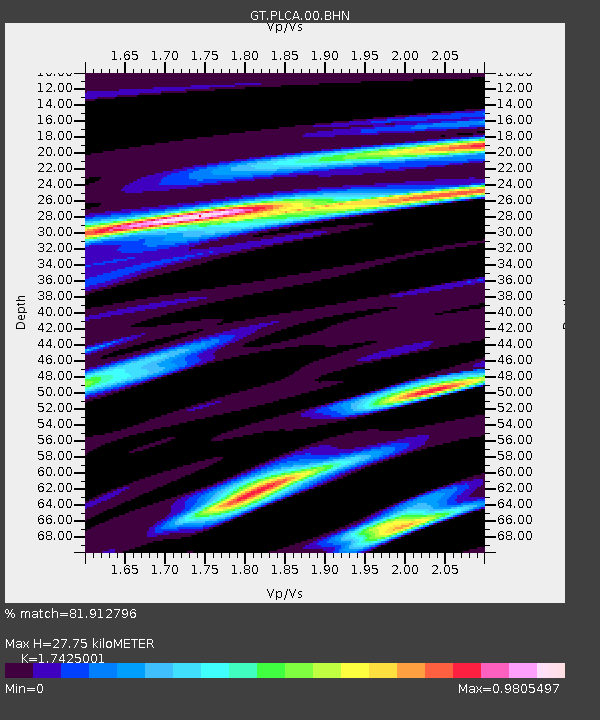
PLCA Paso Flores, Argentina - Earthquake Result Viewer
| Earthquake location: |
South Sandwich Islands Region |
| Earthquake latitude/longitude: |
-58.1/-25.3 |
| Earthquake time(UTC): |
2018/08/14 (226) 03:29:53 GMT |
| Earthquake Depth: |
35 km |
| Earthquake Magnitude: |
6.1 Mww |
| Earthquake Catalog/Contributor: |
NEIC PDE/us |
|
| Network: |
GT Global Telemetered Seismograph Network (USAF/USGS) |
| Station: |
PLCA Paso Flores, Argentina |
| Lat/Lon: |
40.73 S/70.55 W |
| Elevation: |
1050 m |
|
| Distance: |
33.4 deg |
| Az: |
281.309 deg |
| Baz: |
136.766 deg |
| Ray Param: |
0.07815764 |
| Estimated Moho Depth: |
27.75 km |
| Estimated Crust Vp/Vs: |
1.74 |
| Assumed Crust Vp: |
6.597 km/s |
| Estimated Crust Vs: |
3.786 km/s |
| Estimated Crust Poisson's Ratio: |
0.25 |
|
| Radial Match: |
81.912796 % |
| Radial Bump: |
400 |
| Transverse Match: |
56.179897 % |
| Transverse Bump: |
400 |
| SOD ConfigId: |
2825771 |
| Insert Time: |
2018-08-28 03:38:45.654 +0000 |
| GWidth: |
2.5 |
| Max Bumps: |
400 |
| Tol: |
0.001 |
|

Signal To Noise
| Channel | StoN | STA | LTA |
| GT:PLCA:00:BHZ:20180814T03:35:58.524015Z | 7.120364 | 2.7525587E-6 | 3.8657555E-7 |
| GT:PLCA:00:BHN:20180814T03:35:58.524015Z | 5.092037 | 1.3010684E-6 | 2.555104E-7 |
| GT:PLCA:00:BHE:20180814T03:35:58.524015Z | 3.2690191 | 1.0978041E-6 | 3.3582063E-7 |
| Arrivals |
| Ps | 3.4 SECOND |
| PpPs | 11 SECOND |
| PsPs/PpSs | 14 SECOND |


