You are here: Home > Network List > II - Global Seismograph Network (GSN - IRIS/IDA) Stations List
> Station CMLA Cha de Macela, Sao Miguel Island, Azores > Earthquake Result Viewer
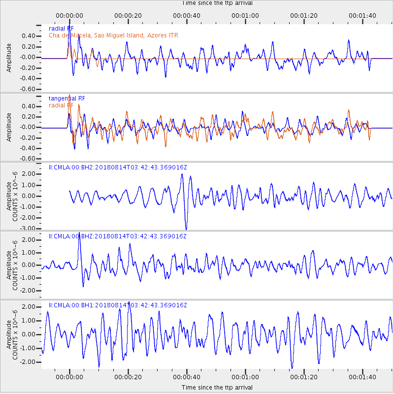
CMLA Cha de Macela, Sao Miguel Island, Azores - Earthquake Result Viewer
*The percent match for this event was below the threshold and hence no stack was calculated.
| Earthquake location: |
South Sandwich Islands Region |
| Earthquake latitude/longitude: |
-58.1/-25.3 |
| Earthquake time(UTC): |
2018/08/14 (226) 03:29:53 GMT |
| Earthquake Depth: |
35 km |
| Earthquake Magnitude: |
6.1 Mww |
| Earthquake Catalog/Contributor: |
NEIC PDE/us |
|
| Network: |
II Global Seismograph Network (GSN - IRIS/IDA) |
| Station: |
CMLA Cha de Macela, Sao Miguel Island, Azores |
| Lat/Lon: |
37.76 N/25.52 W |
| Elevation: |
429 m |
|
| Distance: |
95.5 deg |
| Az: |
359.789 deg |
| Baz: |
179.858 deg |
| Ray Param: |
$rayparam |
*The percent match for this event was below the threshold and hence was not used in the summary stack. |
|
| Radial Match: |
62.031322 % |
| Radial Bump: |
400 |
| Transverse Match: |
54.340714 % |
| Transverse Bump: |
326 |
| SOD ConfigId: |
2825771 |
| Insert Time: |
2018-08-28 03:38:51.897 +0000 |
| GWidth: |
2.5 |
| Max Bumps: |
400 |
| Tol: |
0.001 |
|
Signal To Noise
| Channel | StoN | STA | LTA |
| II:CMLA:00:BHZ:20180814T03:42:43.369016Z | 3.6471999 | 9.3170183E-7 | 2.5545677E-7 |
| II:CMLA:00:BH1:20180814T03:42:43.369016Z | 1.0418535 | 6.99742E-7 | 6.716318E-7 |
| II:CMLA:00:BH2:20180814T03:42:43.369016Z | 1.499796 | 5.594255E-7 | 3.7300106E-7 |
| Arrivals |
| Ps | |
| PpPs | |
| PsPs/PpSs | |


