You are here: Home > Network List > US - United States National Seismic Network Stations List
> Station MNTX Cornudas Mountains, Texas, USA > Earthquake Result Viewer
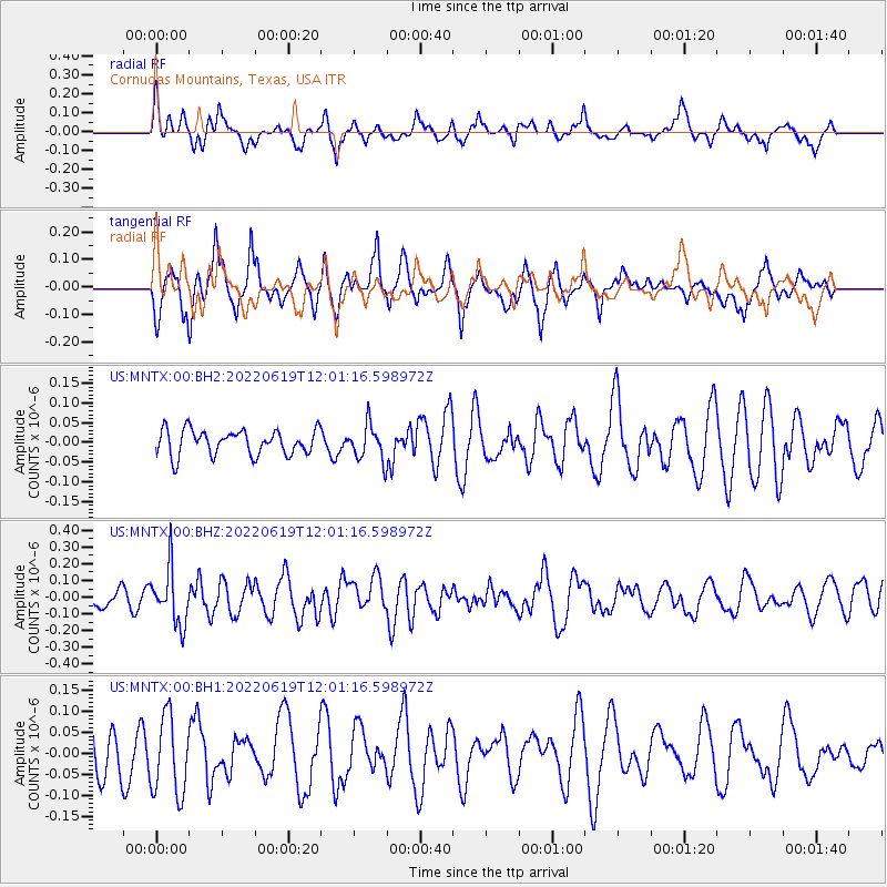
MNTX Cornudas Mountains, Texas, USA - Earthquake Result Viewer
*The percent match for this event was below the threshold and hence no stack was calculated.
| Earthquake location: |
Tonga Islands |
| Earthquake latitude/longitude: |
-20.3/-174.8 |
| Earthquake time(UTC): |
2022/06/19 (170) 11:49:20 GMT |
| Earthquake Depth: |
39 km |
| Earthquake Magnitude: |
5.5 Mww |
| Earthquake Catalog/Contributor: |
NEIC PDE/us |
|
| Network: |
US United States National Seismic Network |
| Station: |
MNTX Cornudas Mountains, Texas, USA |
| Lat/Lon: |
31.70 N/105.38 W |
| Elevation: |
405 m |
|
| Distance: |
84.2 deg |
| Az: |
53.33 deg |
| Baz: |
242.002 deg |
| Ray Param: |
$rayparam |
*The percent match for this event was below the threshold and hence was not used in the summary stack. |
|
| Radial Match: |
64.20523 % |
| Radial Bump: |
400 |
| Transverse Match: |
61.78157 % |
| Transverse Bump: |
384 |
| SOD ConfigId: |
28208852 |
| Insert Time: |
2022-07-03 12:08:47.427 +0000 |
| GWidth: |
2.5 |
| Max Bumps: |
400 |
| Tol: |
0.001 |
|
Signal To Noise
| Channel | StoN | STA | LTA |
| US:MNTX:00:BHZ:20220619T12:01:16.598972Z | 1.9988666 | 1.648574E-7 | 8.247544E-8 |
| US:MNTX:00:BH1:20220619T12:01:16.598972Z | 1.0674514 | 9.30102E-8 | 8.713296E-8 |
| US:MNTX:00:BH2:20220619T12:01:16.598972Z | 1.4038372 | 4.469982E-8 | 3.184117E-8 |
| Arrivals |
| Ps | |
| PpPs | |
| PsPs/PpSs | |


