You are here: Home > Network List > AK - Alaska Regional Network Stations List
> Station E18K Tukpahlearik Creek, AK, USA > Earthquake Result Viewer
E18K Tukpahlearik Creek, AK, USA - Earthquake Result Viewer
| Earthquake location: |
Taiwan |
| Earthquake latitude/longitude: |
23.7/121.5 |
| Earthquake time(UTC): |
2022/06/20 (171) 01:05:07 GMT |
| Earthquake Depth: |
8.0 km |
| Earthquake Magnitude: |
5.9 mww |
| Earthquake Catalog/Contributor: |
NEIC PDE/us |
|
| Network: |
AK Alaska Regional Network |
| Station: |
E18K Tukpahlearik Creek, AK, USA |
| Lat/Lon: |
67.42 N/160.60 W |
| Elevation: |
297 m |
|
| Distance: |
63.8 deg |
| Az: |
24.897 deg |
| Baz: |
268.539 deg |
| Ray Param: |
0.05937381 |
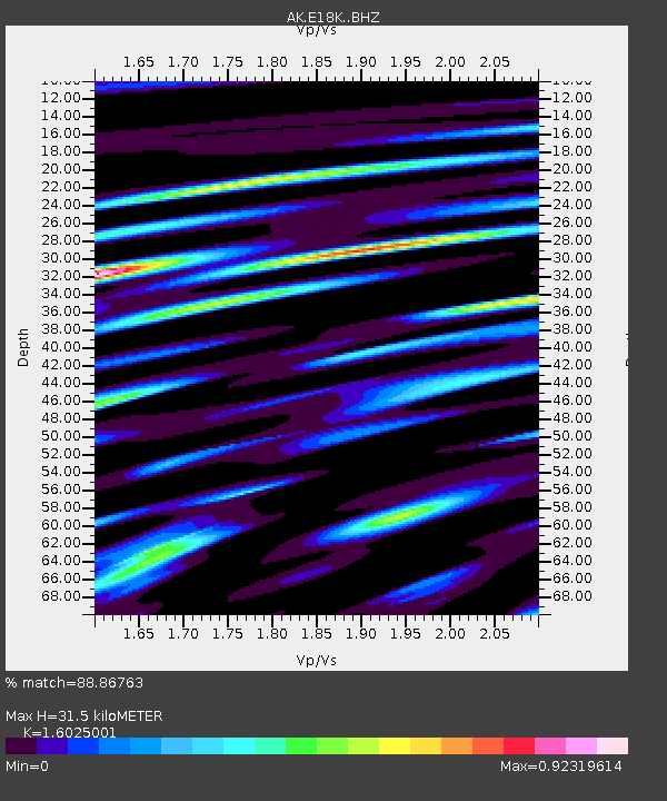
| Estimated Moho Depth: |
31.5 km |
| Estimated Crust Vp/Vs: |
1.60 |
| Assumed Crust Vp: |
6.276 km/s |
| Estimated Crust Vs: |
3.916 km/s |
| Estimated Crust Poisson's Ratio: |
0.18 |
|
| Radial Match: |
88.86763 % |
| Radial Bump: |
400 |
| Transverse Match: |
79.530045 % |
| Transverse Bump: |
400 |
| SOD ConfigId: |
28208852 |
| Insert Time: |
2022-07-04 01:08:21.698 +0000 |
| GWidth: |
2.5 |
| Max Bumps: |
400 |
| Tol: |
0.001 |
|

Signal To Noise
| Channel | StoN | STA | LTA |
| AK:E18K: :BHZ:20220620T01:15:08.44001Z | 13.969273 | 8.803317E-7 | 6.301915E-8 |
| AK:E18K: :BHN:20220620T01:15:08.44001Z | 2.114766 | 5.9403074E-8 | 2.808967E-8 |
| AK:E18K: :BHE:20220620T01:15:08.44001Z | 11.5722065 | 3.715586E-7 | 3.210784E-8 |
| Arrivals |
| Ps | 3.2 SECOND |
| PpPs | 12 SECOND |
| PsPs/PpSs | 16 SECOND |


