You are here: Home > Network List > PF - Volcanologic Network of Piton de Fournaise-OVPF Stations List
> Station HIM cratere Himiltrude > Earthquake Result Viewer
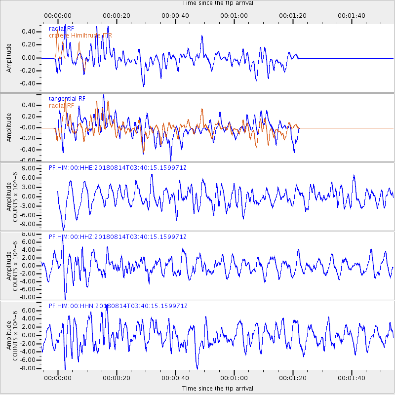
HIM cratere Himiltrude - Earthquake Result Viewer
*The percent match for this event was below the threshold and hence no stack was calculated.
| Earthquake location: |
South Sandwich Islands Region |
| Earthquake latitude/longitude: |
-58.1/-25.3 |
| Earthquake time(UTC): |
2018/08/14 (226) 03:29:53 GMT |
| Earthquake Depth: |
35 km |
| Earthquake Magnitude: |
6.1 Mww |
| Earthquake Catalog/Contributor: |
NEIC PDE/us |
|
| Network: |
PF Volcanologic Network of Piton de Fournaise-OVPF |
| Station: |
HIM cratere Himiltrude |
| Lat/Lon: |
21.21 S/55.72 E |
| Elevation: |
1958 m |
|
| Distance: |
67.5 deg |
| Az: |
94.156 deg |
| Baz: |
214.571 deg |
| Ray Param: |
$rayparam |
*The percent match for this event was below the threshold and hence was not used in the summary stack. |
|
| Radial Match: |
67.15667 % |
| Radial Bump: |
400 |
| Transverse Match: |
55.3327 % |
| Transverse Bump: |
400 |
| SOD ConfigId: |
2825771 |
| Insert Time: |
2018-08-28 03:40:01.926 +0000 |
| GWidth: |
2.5 |
| Max Bumps: |
400 |
| Tol: |
0.001 |
|
Signal To Noise
| Channel | StoN | STA | LTA |
| PF:HIM:00:HHZ:20180814T03:40:15.159971Z | 2.5364892 | 3.6165727E-6 | 1.4258183E-6 |
| PF:HIM:00:HHN:20180814T03:40:15.159971Z | 1.8818221 | 3.3445465E-6 | 1.7772915E-6 |
| PF:HIM:00:HHE:20180814T03:40:15.159971Z | 0.8275979 | 3.006127E-6 | 3.6323518E-6 |
| Arrivals |
| Ps | |
| PpPs | |
| PsPs/PpSs | |


