You are here: Home > Network List > AK - Alaska Regional Network Stations List
> Station N15K Kwethluk River, AK, USA > Earthquake Result Viewer
N15K Kwethluk River, AK, USA - Earthquake Result Viewer
| Earthquake location: |
Taiwan |
| Earthquake latitude/longitude: |
23.7/121.5 |
| Earthquake time(UTC): |
2022/06/20 (171) 01:05:07 GMT |
| Earthquake Depth: |
8.0 km |
| Earthquake Magnitude: |
5.9 mww |
| Earthquake Catalog/Contributor: |
NEIC PDE/us |
|
| Network: |
AK Alaska Regional Network |
| Station: |
N15K Kwethluk River, AK, USA |
| Lat/Lon: |
60.17 N/160.09 W |
| Elevation: |
449 m |
|
| Distance: |
64.1 deg |
| Az: |
33.004 deg |
| Baz: |
272.567 deg |
| Ray Param: |
0.05917656 |
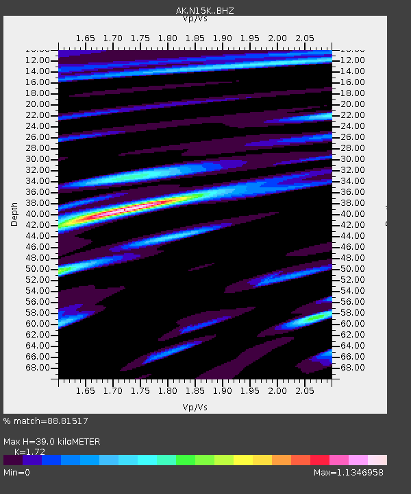
| Estimated Moho Depth: |
39.0 km |
| Estimated Crust Vp/Vs: |
1.72 |
| Assumed Crust Vp: |
6.182 km/s |
| Estimated Crust Vs: |
3.594 km/s |
| Estimated Crust Poisson's Ratio: |
0.24 |
|
| Radial Match: |
88.81517 % |
| Radial Bump: |
400 |
| Transverse Match: |
74.13382 % |
| Transverse Bump: |
400 |
| SOD ConfigId: |
28208852 |
| Insert Time: |
2022-07-04 01:10:20.548 +0000 |
| GWidth: |
2.5 |
| Max Bumps: |
400 |
| Tol: |
0.001 |
|

Signal To Noise
| Channel | StoN | STA | LTA |
| AK:N15K: :BHZ:20220620T01:15:10.399971Z | 20.128029 | 1.2916494E-6 | 6.417167E-8 |
| AK:N15K: :BHN:20220620T01:15:10.399971Z | 2.3485723 | 1.4502781E-7 | 6.175148E-8 |
| AK:N15K: :BHE:20220620T01:15:10.399971Z | 7.598195 | 4.397841E-7 | 5.7880072E-8 |
| Arrivals |
| Ps | 4.7 SECOND |
| PpPs | 16 SECOND |
| PsPs/PpSs | 21 SECOND |


