You are here: Home > Network List > WI - West Indies IPGP Network Stations List
> Station BIM Morne Bigot, Anses d'Arlets, Martinique > Earthquake Result Viewer
BIM Morne Bigot, Anses d'Arlets, Martinique - Earthquake Result Viewer
| Earthquake location: |
South Sandwich Islands Region |
| Earthquake latitude/longitude: |
-58.1/-25.3 |
| Earthquake time(UTC): |
2018/08/14 (226) 03:29:53 GMT |
| Earthquake Depth: |
35 km |
| Earthquake Magnitude: |
6.1 Mww |
| Earthquake Catalog/Contributor: |
NEIC PDE/us |
|
| Network: |
WI West Indies IPGP Network |
| Station: |
BIM Morne Bigot, Anses d'Arlets, Martinique |
| Lat/Lon: |
14.52 N/61.07 W |
| Elevation: |
391 m |
|
| Distance: |
78.1 deg |
| Az: |
324.619 deg |
| Baz: |
161.496 deg |
| Ray Param: |
0.0498061 |
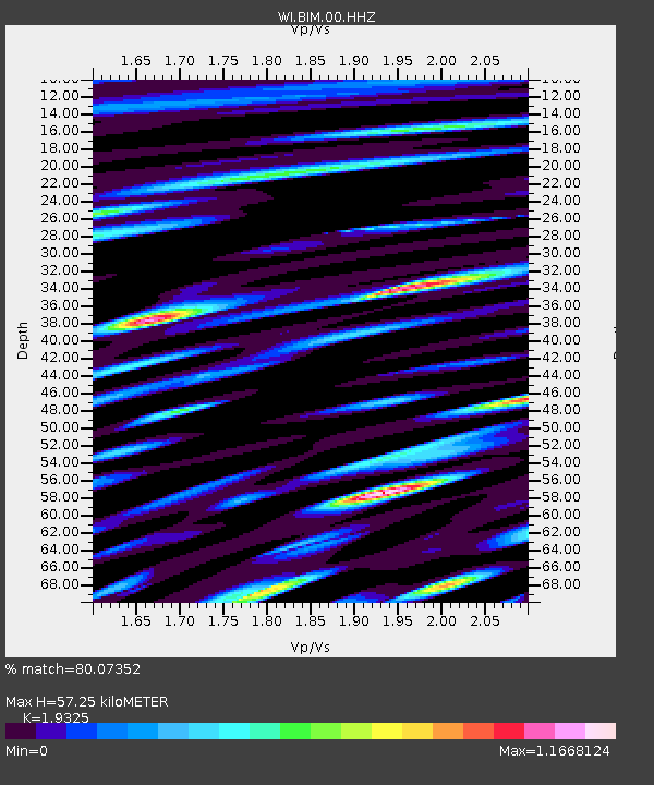
| Estimated Moho Depth: |
57.25 km |
| Estimated Crust Vp/Vs: |
1.93 |
| Assumed Crust Vp: |
5.88 km/s |
| Estimated Crust Vs: |
3.043 km/s |
| Estimated Crust Poisson's Ratio: |
0.32 |
|
| Radial Match: |
80.07352 % |
| Radial Bump: |
400 |
| Transverse Match: |
85.84635 % |
| Transverse Bump: |
400 |
| SOD ConfigId: |
2825771 |
| Insert Time: |
2018-08-28 03:40:26.695 +0000 |
| GWidth: |
2.5 |
| Max Bumps: |
400 |
| Tol: |
0.001 |
|
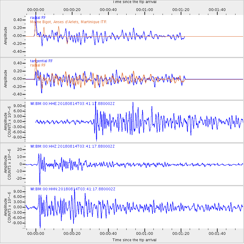
Signal To Noise
| Channel | StoN | STA | LTA |
| WI:BIM:00:HHZ:20180814T03:41:17.880002Z | 27.521135 | 8.720345E-6 | 3.1685994E-7 |
| WI:BIM:00:HHN:20180814T03:41:17.880002Z | 6.727627 | 3.7594673E-6 | 5.588103E-7 |
| WI:BIM:00:HHE:20180814T03:41:17.880002Z | 7.4190736 | 4.052305E-6 | 5.462009E-7 |
| Arrivals |
| Ps | 9.3 SECOND |
| PpPs | 28 SECOND |
| PsPs/PpSs | 37 SECOND |


