You are here: Home > Network List > AK - Alaska Regional Network Stations List
> Station HIN Hinchinbrook, AK, USA > Earthquake Result Viewer
HIN Hinchinbrook, AK, USA - Earthquake Result Viewer
| Earthquake location: |
Bonin Islands, Japan Region |
| Earthquake latitude/longitude: |
28.0/142.8 |
| Earthquake time(UTC): |
2022/06/21 (172) 07:14:54 GMT |
| Earthquake Depth: |
10 km |
| Earthquake Magnitude: |
5.9 mww |
| Earthquake Catalog/Contributor: |
NEIC PDE/us |
|
| Network: |
AK Alaska Regional Network |
| Station: |
HIN Hinchinbrook, AK, USA |
| Lat/Lon: |
60.40 N/146.50 W |
| Elevation: |
623 m |
|
| Distance: |
56.6 deg |
| Az: |
34.131 deg |
| Baz: |
268.459 deg |
| Ray Param: |
0.06402184 |
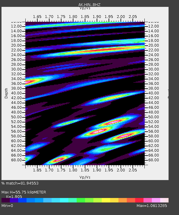
| Estimated Moho Depth: |
55.75 km |
| Estimated Crust Vp/Vs: |
1.90 |
| Assumed Crust Vp: |
6.566 km/s |
| Estimated Crust Vs: |
3.447 km/s |
| Estimated Crust Poisson's Ratio: |
0.31 |
|
| Radial Match: |
81.94553 % |
| Radial Bump: |
400 |
| Transverse Match: |
80.66082 % |
| Transverse Bump: |
400 |
| SOD ConfigId: |
28208852 |
| Insert Time: |
2022-07-05 07:18:59.714 +0000 |
| GWidth: |
2.5 |
| Max Bumps: |
400 |
| Tol: |
0.001 |
|

Signal To Noise
| Channel | StoN | STA | LTA |
| AK:HIN: :BHZ:20220621T07:24:06.147996Z | 4.5632334 | 4.4933273E-7 | 9.8468064E-8 |
| AK:HIN: :BHN:20220621T07:24:06.147996Z | 1.2661395 | 1.4208999E-7 | 1.1222301E-7 |
| AK:HIN: :BHE:20220621T07:24:06.147996Z | 1.6378883 | 1.9270982E-7 | 1.1765748E-7 |
| Arrivals |
| Ps | 8.1 SECOND |
| PpPs | 23 SECOND |
| PsPs/PpSs | 32 SECOND |


