You are here: Home > Network List > AK - Alaska Regional Network Stations List
> Station K20K Telida, AK, USA > Earthquake Result Viewer
K20K Telida, AK, USA - Earthquake Result Viewer
| Earthquake location: |
Bonin Islands, Japan Region |
| Earthquake latitude/longitude: |
28.0/142.8 |
| Earthquake time(UTC): |
2022/06/21 (172) 07:14:54 GMT |
| Earthquake Depth: |
10 km |
| Earthquake Magnitude: |
5.9 mww |
| Earthquake Catalog/Contributor: |
NEIC PDE/us |
|
| Network: |
AK Alaska Regional Network |
| Station: |
K20K Telida, AK, USA |
| Lat/Lon: |
63.36 N/154.07 W |
| Elevation: |
548 m |
|
| Distance: |
53.4 deg |
| Az: |
30.07 deg |
| Baz: |
259.461 deg |
| Ray Param: |
0.06615748 |
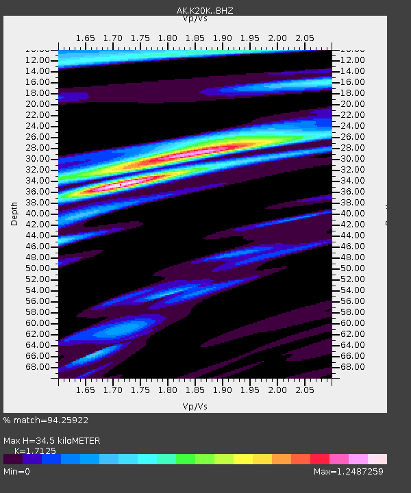
| Estimated Moho Depth: |
34.5 km |
| Estimated Crust Vp/Vs: |
1.71 |
| Assumed Crust Vp: |
6.438 km/s |
| Estimated Crust Vs: |
3.76 km/s |
| Estimated Crust Poisson's Ratio: |
0.24 |
|
| Radial Match: |
94.25922 % |
| Radial Bump: |
336 |
| Transverse Match: |
86.659386 % |
| Transverse Bump: |
400 |
| SOD ConfigId: |
28208852 |
| Insert Time: |
2022-07-05 07:19:20.989 +0000 |
| GWidth: |
2.5 |
| Max Bumps: |
400 |
| Tol: |
0.001 |
|

Signal To Noise
| Channel | StoN | STA | LTA |
| AK:K20K: :BHZ:20220621T07:23:42.66002Z | 8.614126 | 4.5072937E-7 | 5.232444E-8 |
| AK:K20K: :BHN:20220621T07:23:42.66002Z | 1.9444027 | 7.330169E-8 | 3.7698825E-8 |
| AK:K20K: :BHE:20220621T07:23:42.66002Z | 6.0702357 | 2.323141E-7 | 3.8271015E-8 |
| Arrivals |
| Ps | 4.0 SECOND |
| PpPs | 14 SECOND |
| PsPs/PpSs | 18 SECOND |


