You are here: Home > Network List > AK - Alaska Regional Network Stations List
> Station L17K Donlin, AK, USA > Earthquake Result Viewer
L17K Donlin, AK, USA - Earthquake Result Viewer
| Earthquake location: |
Bonin Islands, Japan Region |
| Earthquake latitude/longitude: |
28.0/142.8 |
| Earthquake time(UTC): |
2022/06/21 (172) 07:14:54 GMT |
| Earthquake Depth: |
10 km |
| Earthquake Magnitude: |
5.9 mww |
| Earthquake Catalog/Contributor: |
NEIC PDE/us |
|
| Network: |
AK Alaska Regional Network |
| Station: |
L17K Donlin, AK, USA |
| Lat/Lon: |
62.13 N/158.30 W |
| Elevation: |
338 m |
|
| Distance: |
51.2 deg |
| Az: |
31.07 deg |
| Baz: |
256.319 deg |
| Ray Param: |
0.0675638 |
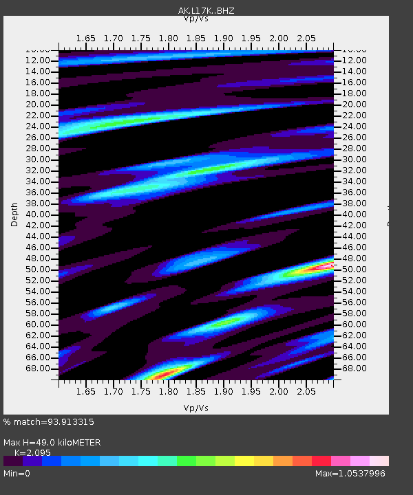
| Estimated Moho Depth: |
49.0 km |
| Estimated Crust Vp/Vs: |
2.10 |
| Assumed Crust Vp: |
6.276 km/s |
| Estimated Crust Vs: |
2.996 km/s |
| Estimated Crust Poisson's Ratio: |
0.35 |
|
| Radial Match: |
93.913315 % |
| Radial Bump: |
400 |
| Transverse Match: |
81.45322 % |
| Transverse Bump: |
400 |
| SOD ConfigId: |
28208852 |
| Insert Time: |
2022-07-05 07:19:32.498 +0000 |
| GWidth: |
2.5 |
| Max Bumps: |
400 |
| Tol: |
0.001 |
|

Signal To Noise
| Channel | StoN | STA | LTA |
| AK:L17K: :BHZ:20220621T07:23:26.66002Z | 6.5038166 | 3.510546E-7 | 5.3976706E-8 |
| AK:L17K: :BHN:20220621T07:23:26.66002Z | 1.5147581 | 5.182856E-8 | 3.4215734E-8 |
| AK:L17K: :BHE:20220621T07:23:26.66002Z | 5.297201 | 1.9152534E-7 | 3.6155953E-8 |
| Arrivals |
| Ps | 8.9 SECOND |
| PpPs | 23 SECOND |
| PsPs/PpSs | 32 SECOND |


