You are here: Home > Network List > AV - Alaska Volcano Observatory Stations List
> Station ACH Angle Creek Headwaters, Katmai, Alaska > Earthquake Result Viewer
ACH Angle Creek Headwaters, Katmai, Alaska - Earthquake Result Viewer
| Earthquake location: |
Bonin Islands, Japan Region |
| Earthquake latitude/longitude: |
28.0/142.8 |
| Earthquake time(UTC): |
2022/06/21 (172) 07:14:54 GMT |
| Earthquake Depth: |
10 km |
| Earthquake Magnitude: |
5.9 mww |
| Earthquake Catalog/Contributor: |
NEIC PDE/us |
|
| Network: |
AV Alaska Volcano Observatory |
| Station: |
ACH Angle Creek Headwaters, Katmai, Alaska |
| Lat/Lon: |
58.21 N/155.33 W |
| Elevation: |
960 m |
|
| Distance: |
51.9 deg |
| Az: |
36.36 deg |
| Baz: |
262.182 deg |
| Ray Param: |
0.067088 |
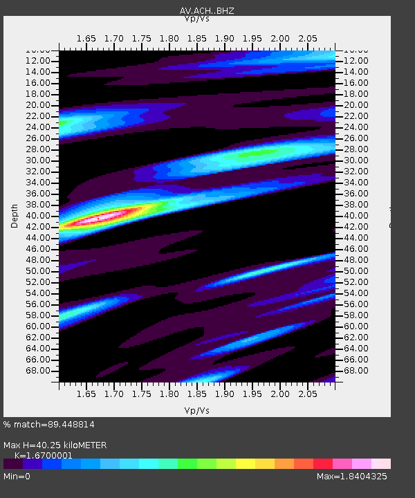
| Estimated Moho Depth: |
40.25 km |
| Estimated Crust Vp/Vs: |
1.67 |
| Assumed Crust Vp: |
6.438 km/s |
| Estimated Crust Vs: |
3.855 km/s |
| Estimated Crust Poisson's Ratio: |
0.22 |
|
| Radial Match: |
89.448814 % |
| Radial Bump: |
287 |
| Transverse Match: |
84.080284 % |
| Transverse Bump: |
361 |
| SOD ConfigId: |
28208852 |
| Insert Time: |
2022-07-05 07:22:22.534 +0000 |
| GWidth: |
2.5 |
| Max Bumps: |
400 |
| Tol: |
0.001 |
|

Signal To Noise
| Channel | StoN | STA | LTA |
| AV:ACH: :BHZ:20220621T07:23:32.067979Z | 7.6310987 | 3.0242956E-7 | 3.9631193E-8 |
| AV:ACH: :BHN:20220621T07:23:32.067979Z | 3.1735795 | 1.2922854E-7 | 4.072012E-8 |
| AV:ACH: :BHE:20220621T07:23:32.067979Z | 5.325638 | 2.3063886E-7 | 4.3307278E-8 |
| Arrivals |
| Ps | 4.4 SECOND |
| PpPs | 16 SECOND |
| PsPs/PpSs | 20 SECOND |


