You are here: Home > Network List > AV - Alaska Volcano Observatory Stations List
> Station WAZA Wrangell Zanetti, Alaska > Earthquake Result Viewer
WAZA Wrangell Zanetti, Alaska - Earthquake Result Viewer
| Earthquake location: |
Bonin Islands, Japan Region |
| Earthquake latitude/longitude: |
28.0/142.8 |
| Earthquake time(UTC): |
2022/06/21 (172) 07:14:54 GMT |
| Earthquake Depth: |
10 km |
| Earthquake Magnitude: |
5.9 mww |
| Earthquake Catalog/Contributor: |
NEIC PDE/us |
|
| Network: |
AV Alaska Volcano Observatory |
| Station: |
WAZA Wrangell Zanetti, Alaska |
| Lat/Lon: |
62.07 N/144.15 W |
| Elevation: |
2531 m |
|
| Distance: |
57.8 deg |
| Az: |
32.152 deg |
| Baz: |
269.444 deg |
| Ray Param: |
0.063265376 |
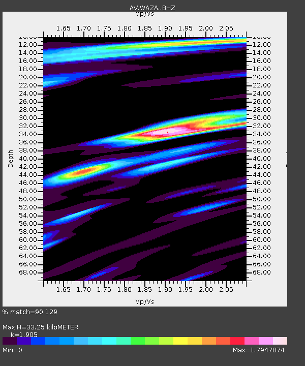
| Estimated Moho Depth: |
33.25 km |
| Estimated Crust Vp/Vs: |
1.90 |
| Assumed Crust Vp: |
6.566 km/s |
| Estimated Crust Vs: |
3.447 km/s |
| Estimated Crust Poisson's Ratio: |
0.31 |
|
| Radial Match: |
90.129 % |
| Radial Bump: |
400 |
| Transverse Match: |
90.09322 % |
| Transverse Bump: |
400 |
| SOD ConfigId: |
28208852 |
| Insert Time: |
2022-07-05 07:24:24.986 +0000 |
| GWidth: |
2.5 |
| Max Bumps: |
400 |
| Tol: |
0.001 |
|

Signal To Noise
| Channel | StoN | STA | LTA |
| AV:WAZA: :BHZ:20220621T07:24:14.379991Z | 6.616965 | 5.0491997E-7 | 7.630688E-8 |
| AV:WAZA: :BHN:20220621T07:24:14.379991Z | 1.1182239 | 9.110863E-8 | 8.14762E-8 |
| AV:WAZA: :BHE:20220621T07:24:14.379991Z | 2.5306983 | 2.0746357E-7 | 8.197878E-8 |
| Arrivals |
| Ps | 4.8 SECOND |
| PpPs | 14 SECOND |
| PsPs/PpSs | 19 SECOND |


