You are here: Home > Network List > C0 - Colorado Geological Survey Seismic Network Stations List
> Station N23A Red Feather Lakes, CO > Earthquake Result Viewer
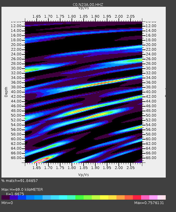
N23A Red Feather Lakes, CO - Earthquake Result Viewer
| Earthquake location: |
Bonin Islands, Japan Region |
| Earthquake latitude/longitude: |
28.0/142.8 |
| Earthquake time(UTC): |
2022/06/21 (172) 07:14:54 GMT |
| Earthquake Depth: |
10 km |
| Earthquake Magnitude: |
5.9 mww |
| Earthquake Catalog/Contributor: |
NEIC PDE/us |
|
| Network: |
C0 Colorado Geological Survey Seismic Network |
| Station: |
N23A Red Feather Lakes, CO |
| Lat/Lon: |
40.89 N/105.94 W |
| Elevation: |
2452 m |
|
| Distance: |
86.5 deg |
| Az: |
45.065 deg |
| Baz: |
304.306 deg |
| Ray Param: |
0.04401338 |
| Estimated Moho Depth: |
69.0 km |
| Estimated Crust Vp/Vs: |
1.67 |
| Assumed Crust Vp: |
6.306 km/s |
| Estimated Crust Vs: |
3.782 km/s |
| Estimated Crust Poisson's Ratio: |
0.22 |
|
| Radial Match: |
91.84657 % |
| Radial Bump: |
400 |
| Transverse Match: |
86.806206 % |
| Transverse Bump: |
400 |
| SOD ConfigId: |
28208852 |
| Insert Time: |
2022-07-05 07:25:54.302 +0000 |
| GWidth: |
2.5 |
| Max Bumps: |
400 |
| Tol: |
0.001 |
|

Signal To Noise
| Channel | StoN | STA | LTA |
| C0:N23A:00:HHZ:20220621T07:27:05.499009Z | 2.9308357 | 2.8011488E-7 | 9.557508E-8 |
| C0:N23A:00:HHN:20220621T07:27:05.499009Z | 2.2447515 | 1.2994244E-7 | 5.7887227E-8 |
| C0:N23A:00:HHE:20220621T07:27:05.499009Z | 2.5306199 | 1.08161856E-7 | 4.274125E-8 |
| Arrivals |
| Ps | 7.5 SECOND |
| PpPs | 29 SECOND |
| PsPs/PpSs | 36 SECOND |


