You are here: Home > Network List > GS - US Geological Survey Networks Stations List
> Station NE02 NE02 Southeast of Arnold, NE > Earthquake Result Viewer
NE02 NE02 Southeast of Arnold, NE - Earthquake Result Viewer
| Earthquake location: |
Andreanof Islands, Aleutian Is. |
| Earthquake latitude/longitude: |
51.4/-178.1 |
| Earthquake time(UTC): |
2018/08/15 (227) 21:56:54 GMT |
| Earthquake Depth: |
20 km |
| Earthquake Magnitude: |
6.6 Mww |
| Earthquake Catalog/Contributor: |
NEIC PDE/us |
|
| Network: |
GS US Geological Survey Networks |
| Station: |
NE02 NE02 Southeast of Arnold, NE |
| Lat/Lon: |
41.35 N/100.09 W |
| Elevation: |
817 m |
|
| Distance: |
52.3 deg |
| Az: |
68.532 deg |
| Baz: |
309.306 deg |
| Ray Param: |
0.06682572 |
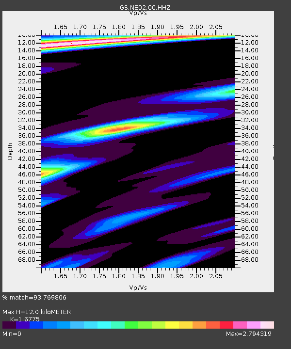
| Estimated Moho Depth: |
12.0 km |
| Estimated Crust Vp/Vs: |
1.68 |
| Assumed Crust Vp: |
6.483 km/s |
| Estimated Crust Vs: |
3.864 km/s |
| Estimated Crust Poisson's Ratio: |
0.22 |
|
| Radial Match: |
93.769806 % |
| Radial Bump: |
366 |
| Transverse Match: |
85.2167 % |
| Transverse Bump: |
400 |
| SOD ConfigId: |
2825771 |
| Insert Time: |
2018-08-29 22:05:41.277 +0000 |
| GWidth: |
2.5 |
| Max Bumps: |
400 |
| Tol: |
0.001 |
|

Signal To Noise
| Channel | StoN | STA | LTA |
| GS:NE02:00:HHZ:20180815T22:05:33.92801Z | 51.718918 | 3.8712647E-6 | 7.4852E-8 |
| GS:NE02:00:HH1:20180815T22:05:33.92801Z | 10.901803 | 2.0066916E-6 | 1.8406969E-7 |
| GS:NE02:00:HH2:20180815T22:05:33.92801Z | 16.40178 | 2.2919162E-6 | 1.3973583E-7 |
| Arrivals |
| Ps | 1.3 SECOND |
| PpPs | 4.7 SECOND |
| PsPs/PpSs | 6.0 SECOND |


