You are here: Home > Network List > II - Global Seismograph Network (GSN - IRIS/IDA) Stations List
> Station CMLA Cha de Macela, Sao Miguel Island, Azores > Earthquake Result Viewer
CMLA Cha de Macela, Sao Miguel Island, Azores - Earthquake Result Viewer

| Earthquake location: |
Andreanof Islands, Aleutian Is. |
| Earthquake latitude/longitude: |
51.4/-178.1 |
| Earthquake time(UTC): |
2018/08/15 (227) 21:56:54 GMT |
| Earthquake Depth: |
20 km |
| Earthquake Magnitude: |
6.6 Mww |
| Earthquake Catalog/Contributor: |
NEIC PDE/us |
|
| Network: |
II Global Seismograph Network (GSN - IRIS/IDA) |
| Station: |
CMLA Cha de Macela, Sao Miguel Island, Azores |
| Lat/Lon: |
37.76 N/25.52 W |
| Elevation: |
429 m |
|
| Distance: |
88.0 deg |
| Az: |
21.457 deg |
| Baz: |
343.206 deg |
| Ray Param: |
0.042917266 |
| Estimated Moho Depth: |
64.0 km |
| Estimated Crust Vp/Vs: |
1.78 |
| Assumed Crust Vp: |
4.802 km/s |
| Estimated Crust Vs: |
2.694 km/s |
| Estimated Crust Poisson's Ratio: |
0.27 |
|
| Radial Match: |
83.53558 % |
| Radial Bump: |
400 |
| Transverse Match: |
78.22188 % |
| Transverse Bump: |
400 |
| SOD ConfigId: |
2825771 |
| Insert Time: |
2018-08-29 22:05:58.065 +0000 |
| GWidth: |
2.5 |
| Max Bumps: |
400 |
| Tol: |
0.001 |
|
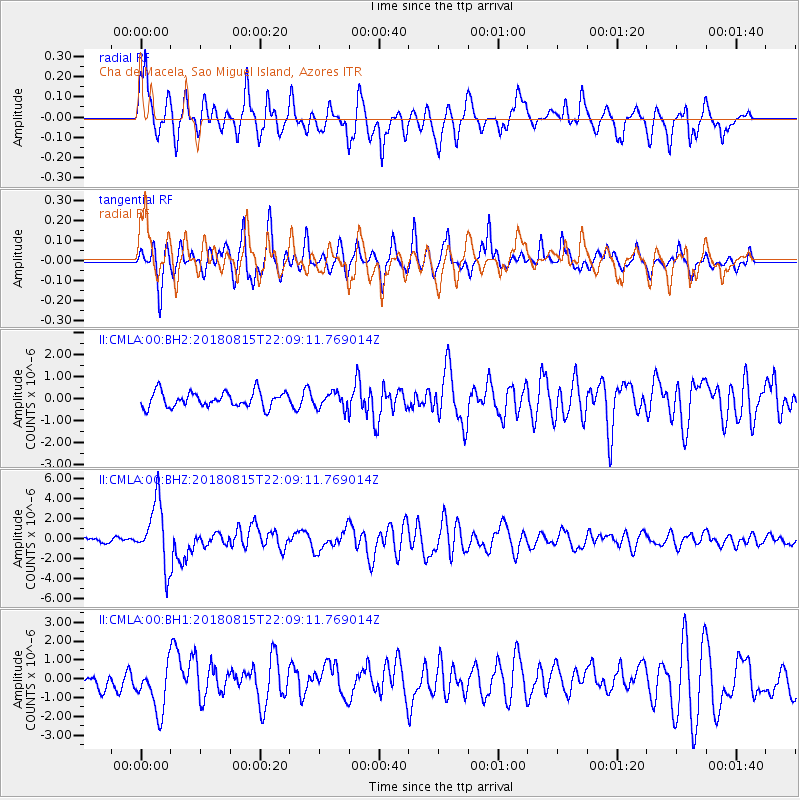
Signal To Noise
| Channel | StoN | STA | LTA |
| II:CMLA:00:BHZ:20180815T22:09:11.769014Z | 11.789796 | 3.1458433E-6 | 2.668276E-7 |
| II:CMLA:00:BH1:20180815T22:09:11.769014Z | 3.1424534 | 1.220245E-6 | 3.8830967E-7 |
| II:CMLA:00:BH2:20180815T22:09:11.769014Z | 1.0211765 | 3.547973E-7 | 3.4743977E-7 |
| Arrivals |
| Ps | 11 SECOND |
| PpPs | 37 SECOND |
| PsPs/PpSs | 47 SECOND |


