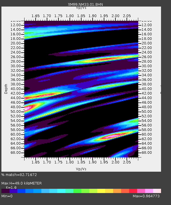
NM33 NewMexico33 - Earthquake Result Viewer

Earthquake location: Alaska Peninsula
Earthquake latitude/longitude: 54.7/-161.2
Earthquake time(UTC): 1999/10/13 (286) 01:33:40 GMT
Earthquake Depth: 30 km
Earthquake Magnitude: 6.0 MB, 6.2 MS, 6.5 MW, 6.0 ML
Earthquake Catalog/Contributor: WHDF/NEIC
Network: XM Rio Grande Seismic Transect
Station: NM33 NewMexico33
Lat/Lon: 35.11 N/107.42 W
Elevation: 2094 m
Distance: 41.6 deg
Az: 95.331 deg
Baz: 315.117 deg
Ray Param: 0.07361942
Estimated Moho Depth: 49.0 km
Estimated Crust Vp/Vs: 1.60
Assumed Crust Vp: 6.502 km/s
Estimated Crust Vs: 4.063 km/s
Estimated Crust Poisson's Ratio: 0.18
Radial Match: 82.71672 %
Radial Bump: 400
Transverse Match: 46.094276 %
Transverse Bump: 400
SOD ConfigId: 27569
Insert Time: 2010-02-26 17:30:24.059 +0000
GWidth: 2.5
Max Bumps: 400
Tol: 0.001

Signal To Noise

ChannelStoNSTALTA
XM:NM33:01:BHN:19991013T01:40:54.933986Z1.13998291.7850098E-71.5658215E-7
XM:NM33:01:BHE:19991013T01:40:54.933986Z0.825723351.5836008E-71.9178346E-7
XM:NM33:01:BHZ:19991013T01:40:54.933986Z2.04022172.1066245E-71.0325469E-7
Arrivals
Ps4.9 SECOND
PpPs18 SECOND
PsPs/PpSs23 SECOND