You are here: Home > Network List > AZ - ANZA Regional Network Stations List
> Station YAQ AZ.YAQ > Earthquake Result Viewer
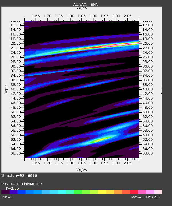
YAQ AZ.YAQ - Earthquake Result Viewer
| Earthquake location: |
Near Coast Of Central Chile |
| Earthquake latitude/longitude: |
-30.8/-71.1 |
| Earthquake time(UTC): |
2002/06/18 (169) 13:56:22 GMT |
| Earthquake Depth: |
54 km |
| Earthquake Magnitude: |
6.0 MB, 6.6 MW, 6.4 MW |
| Earthquake Catalog/Contributor: |
WHDF/NEIC |
|
| Network: |
AZ ANZA Regional Network |
| Station: |
YAQ AZ.YAQ |
| Lat/Lon: |
33.17 N/116.35 W |
| Elevation: |
430 m |
|
| Distance: |
76.7 deg |
| Az: |
322.267 deg |
| Baz: |
141.112 deg |
| Ray Param: |
0.050744798 |
| Estimated Moho Depth: |
20.0 km |
| Estimated Crust Vp/Vs: |
2.05 |
| Assumed Crust Vp: |
6.264 km/s |
| Estimated Crust Vs: |
3.055 km/s |
| Estimated Crust Poisson's Ratio: |
0.34 |
|
| Radial Match: |
93.46916 % |
| Radial Bump: |
400 |
| Transverse Match: |
90.252266 % |
| Transverse Bump: |
400 |
| SOD ConfigId: |
32974 |
| Insert Time: |
2010-03-09 21:25:58.515 +0000 |
| GWidth: |
2.5 |
| Max Bumps: |
400 |
| Tol: |
0.001 |
|

Signal To Noise
| Channel | StoN | STA | LTA |
| AZ:YAQ: :BHN:20020618T14:07:36.97502Z | 2.7001362 | 3.195989E-7 | 1.18364E-7 |
| AZ:YAQ: :BHE:20020618T14:07:36.97502Z | 4.0953765 | 3.956505E-7 | 9.6609064E-8 |
| AZ:YAQ: :BHZ:20020618T14:07:36.97502Z | 12.705463 | 1.6378646E-6 | 1.2891026E-7 |
| Arrivals |
| Ps | 3.4 SECOND |
| PpPs | 9.5 SECOND |
| PsPs/PpSs | 13 SECOND |


