You are here: Home > Network List > AZ - ANZA Regional Network Stations List
> Station YAQ AZ.YAQ > Earthquake Result Viewer
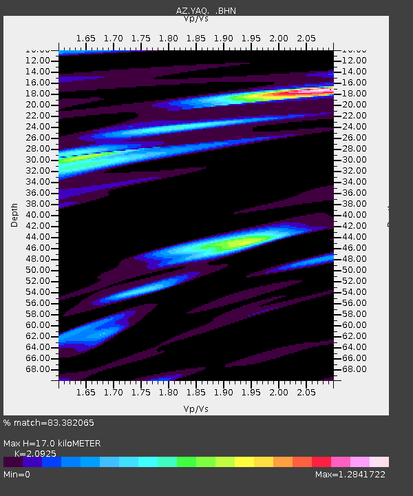
YAQ AZ.YAQ - Earthquake Result Viewer
| Earthquake location: |
Santa Cruz Islands |
| Earthquake latitude/longitude: |
-12.6/166.4 |
| Earthquake time(UTC): |
2002/06/17 (168) 21:26:22 GMT |
| Earthquake Depth: |
33 km |
| Earthquake Magnitude: |
6.0 MB, 6.7 MS, 6.7 MW, 6.6 MW |
| Earthquake Catalog/Contributor: |
WHDF/NEIC |
|
| Network: |
AZ ANZA Regional Network |
| Station: |
YAQ AZ.YAQ |
| Lat/Lon: |
33.17 N/116.35 W |
| Elevation: |
430 m |
|
| Distance: |
86.4 deg |
| Az: |
55.058 deg |
| Baz: |
252.574 deg |
| Ray Param: |
0.044028763 |
| Estimated Moho Depth: |
17.0 km |
| Estimated Crust Vp/Vs: |
2.09 |
| Assumed Crust Vp: |
6.264 km/s |
| Estimated Crust Vs: |
2.993 km/s |
| Estimated Crust Poisson's Ratio: |
0.35 |
|
| Radial Match: |
83.382065 % |
| Radial Bump: |
400 |
| Transverse Match: |
80.87318 % |
| Transverse Bump: |
400 |
| SOD ConfigId: |
32974 |
| Insert Time: |
2010-03-09 21:25:59.911 +0000 |
| GWidth: |
2.5 |
| Max Bumps: |
400 |
| Tol: |
0.001 |
|

Signal To Noise
| Channel | StoN | STA | LTA |
| AZ:YAQ: :BHN:20020617T21:38:30.750017Z | 0.7282729 | 1.1342048E-7 | 1.5573897E-7 |
| AZ:YAQ: :BHE:20020617T21:38:30.750017Z | 0.90042436 | 2.6471776E-7 | 2.9399223E-7 |
| AZ:YAQ: :BHZ:20020617T21:38:30.750017Z | 8.664593 | 8.842507E-7 | 1.0205335E-7 |
| Arrivals |
| Ps | 3.0 SECOND |
| PpPs | 8.2 SECOND |
| PsPs/PpSs | 11 SECOND |


