You are here: Home > Network List > PQ - Public Safety Geoscience Program Canadian Research Network (PSGP) Stations List
> Station NAB2 Zama Lookout Tower, High Level Alberta > Earthquake Result Viewer
NAB2 Zama Lookout Tower, High Level Alberta - Earthquake Result Viewer
| Earthquake location: |
Bonin Islands, Japan Region |
| Earthquake latitude/longitude: |
28.0/142.8 |
| Earthquake time(UTC): |
2022/06/21 (172) 07:14:54 GMT |
| Earthquake Depth: |
10 km |
| Earthquake Magnitude: |
5.9 mww |
| Earthquake Catalog/Contributor: |
NEIC PDE/us |
|
| Network: |
PQ Public Safety Geoscience Program Canadian Research Network (PSGP) |
| Station: |
NAB2 Zama Lookout Tower, High Level Alberta |
| Lat/Lon: |
58.60 N/119.17 W |
| Elevation: |
646 m |
|
| Distance: |
70.6 deg |
| Az: |
33.355 deg |
| Baz: |
291.744 deg |
| Ray Param: |
0.054911137 |
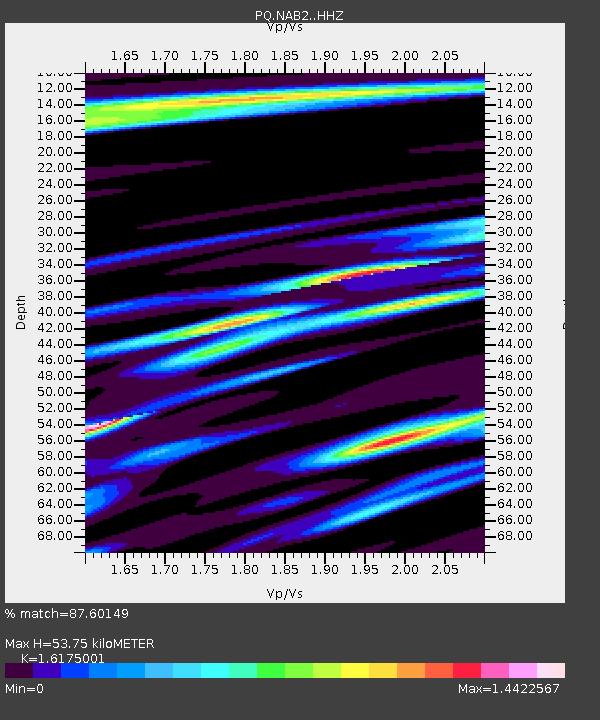
| Estimated Moho Depth: |
53.75 km |
| Estimated Crust Vp/Vs: |
1.62 |
| Assumed Crust Vp: |
6.444 km/s |
| Estimated Crust Vs: |
3.984 km/s |
| Estimated Crust Poisson's Ratio: |
0.19 |
|
| Radial Match: |
87.60149 % |
| Radial Bump: |
400 |
| Transverse Match: |
67.64583 % |
| Transverse Bump: |
400 |
| SOD ConfigId: |
28208852 |
| Insert Time: |
2022-07-05 07:39:45.873 +0000 |
| GWidth: |
2.5 |
| Max Bumps: |
400 |
| Tol: |
0.001 |
|

Signal To Noise
| Channel | StoN | STA | LTA |
| PQ:NAB2: :HHZ:20220621T07:25:38.030015Z | 4.326286 | 3.7153345E-7 | 8.587816E-8 |
| PQ:NAB2: :HHN:20220621T07:25:38.030015Z | 1.3667946 | 2.1083768E-7 | 1.5425705E-7 |
| PQ:NAB2: :HHE:20220621T07:25:38.030015Z | 1.604812 | 2.3411306E-7 | 1.4588193E-7 |
| Arrivals |
| Ps | 5.4 SECOND |
| PpPs | 21 SECOND |
| PsPs/PpSs | 26 SECOND |


