You are here: Home > Network List > AZ - ANZA Regional Network Stations List
> Station YAQ AZ.YAQ > Earthquake Result Viewer
YAQ AZ.YAQ - Earthquake Result Viewer
| Earthquake location: |
Near Coast Of Northern Chile |
| Earthquake latitude/longitude: |
-27.5/-70.6 |
| Earthquake time(UTC): |
2002/04/18 (108) 16:08:36 GMT |
| Earthquake Depth: |
62 km |
| Earthquake Magnitude: |
6.2 MB, 6.7 MW, 6.6 MW |
| Earthquake Catalog/Contributor: |
WHDF/NEIC |
|
| Network: |
AZ ANZA Regional Network |
| Station: |
YAQ AZ.YAQ |
| Lat/Lon: |
33.17 N/116.35 W |
| Elevation: |
430 m |
|
| Distance: |
74.4 deg |
| Az: |
321.39 deg |
| Baz: |
138.651 deg |
| Ray Param: |
0.05223976 |
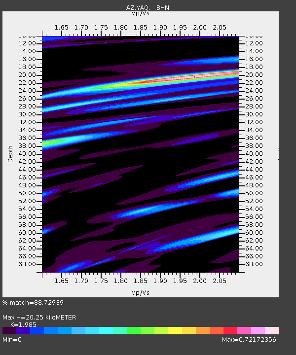
| Estimated Moho Depth: |
20.25 km |
| Estimated Crust Vp/Vs: |
1.99 |
| Assumed Crust Vp: |
6.264 km/s |
| Estimated Crust Vs: |
3.155 km/s |
| Estimated Crust Poisson's Ratio: |
0.33 |
|
| Radial Match: |
88.72939 % |
| Radial Bump: |
400 |
| Transverse Match: |
82.218315 % |
| Transverse Bump: |
400 |
| SOD ConfigId: |
32974 |
| Insert Time: |
2010-03-09 21:26:05.238 +0000 |
| GWidth: |
2.5 |
| Max Bumps: |
400 |
| Tol: |
0.001 |
|

Signal To Noise
| Channel | StoN | STA | LTA |
| AZ:YAQ: :BHN:20020418T16:19:37.05002Z | 0.97792166 | 3.631649E-7 | 3.71364E-7 |
| AZ:YAQ: :BHE:20020418T16:19:37.05002Z | 1.9626303 | 4.9076107E-7 | 2.5005272E-7 |
| AZ:YAQ: :BHZ:20020418T16:19:37.05002Z | 2.4076848 | 9.2089755E-7 | 3.824826E-7 |
| Arrivals |
| Ps | 3.3 SECOND |
| PpPs | 9.4 SECOND |
| PsPs/PpSs | 13 SECOND |


