You are here: Home > Network List > IU - Global Seismograph Network (GSN - IRIS/USGS) Stations List
> Station SLBS Sierra la Laguna Baja California Sur, Mexico > Earthquake Result Viewer
SLBS Sierra la Laguna Baja California Sur, Mexico - Earthquake Result Viewer

| Earthquake location: |
Andreanof Islands, Aleutian Is. |
| Earthquake latitude/longitude: |
51.4/-178.1 |
| Earthquake time(UTC): |
2018/08/15 (227) 21:56:54 GMT |
| Earthquake Depth: |
20 km |
| Earthquake Magnitude: |
6.6 Mww |
| Earthquake Catalog/Contributor: |
NEIC PDE/us |
|
| Network: |
IU Global Seismograph Network (GSN - IRIS/USGS) |
| Station: |
SLBS Sierra la Laguna Baja California Sur, Mexico |
| Lat/Lon: |
23.69 N/109.94 W |
| Elevation: |
825 m |
|
| Distance: |
58.3 deg |
| Az: |
91.111 deg |
| Baz: |
316.947 deg |
| Ray Param: |
0.06291115 |
| Estimated Moho Depth: |
28.5 km |
| Estimated Crust Vp/Vs: |
1.94 |
| Assumed Crust Vp: |
6.183 km/s |
| Estimated Crust Vs: |
3.187 km/s |
| Estimated Crust Poisson's Ratio: |
0.32 |
|
| Radial Match: |
91.51534 % |
| Radial Bump: |
400 |
| Transverse Match: |
79.36275 % |
| Transverse Bump: |
400 |
| SOD ConfigId: |
2825771 |
| Insert Time: |
2018-08-29 22:06:53.725 +0000 |
| GWidth: |
2.5 |
| Max Bumps: |
400 |
| Tol: |
0.001 |
|
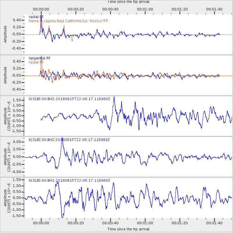
Signal To Noise
| Channel | StoN | STA | LTA |
| IU:SLBS:00:BHZ:20180815T22:06:17.118989Z | 5.243634 | 7.8584486E-7 | 1.4986645E-7 |
| IU:SLBS:00:BH1:20180815T22:06:17.118989Z | 1.9277458 | 3.4132844E-7 | 1.7706091E-7 |
| IU:SLBS:00:BH2:20180815T22:06:17.118989Z | 1.8717899 | 3.2943143E-7 | 1.7599808E-7 |
| Arrivals |
| Ps | 4.5 SECOND |
| PpPs | 13 SECOND |
| PsPs/PpSs | 18 SECOND |


