You are here: Home > Network List > TX - Texas Seismological Network Stations List
> Station PB28 Culberson South > Earthquake Result Viewer
PB28 Culberson South - Earthquake Result Viewer
| Earthquake location: |
Bonin Islands, Japan Region |
| Earthquake latitude/longitude: |
28.0/142.8 |
| Earthquake time(UTC): |
2022/06/21 (172) 07:14:54 GMT |
| Earthquake Depth: |
10 km |
| Earthquake Magnitude: |
5.9 mww |
| Earthquake Catalog/Contributor: |
NEIC PDE/us |
|
| Network: |
TX Texas Seismological Network |
| Station: |
PB28 Culberson South |
| Lat/Lon: |
31.67 N/104.50 W |
| Elevation: |
1204 m |
|
| Distance: |
92.7 deg |
| Az: |
51.96 deg |
| Baz: |
305.207 deg |
| Ray Param: |
0.041410707 |
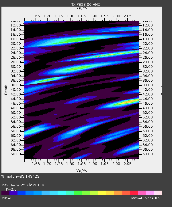
| Estimated Moho Depth: |
24.25 km |
| Estimated Crust Vp/Vs: |
2.00 |
| Assumed Crust Vp: |
6.361 km/s |
| Estimated Crust Vs: |
3.18 km/s |
| Estimated Crust Poisson's Ratio: |
0.33 |
|
| Radial Match: |
85.143425 % |
| Radial Bump: |
400 |
| Transverse Match: |
74.39688 % |
| Transverse Bump: |
390 |
| SOD ConfigId: |
28208852 |
| Insert Time: |
2022-07-05 07:42:10.164 +0000 |
| GWidth: |
2.5 |
| Max Bumps: |
400 |
| Tol: |
0.001 |
|

Signal To Noise
| Channel | StoN | STA | LTA |
| TX:PB28:00:HHZ:20220621T07:27:34.65001Z | 2.3010445 | 1.3749943E-7 | 5.975522E-8 |
| TX:PB28:00:HH1:20220621T07:27:34.65001Z | 1.4699098 | 3.7742748E-8 | 2.5676913E-8 |
| TX:PB28:00:HH2:20220621T07:27:34.65001Z | 1.2751032 | 4.987965E-8 | 3.9118127E-8 |
| Arrivals |
| Ps | 3.9 SECOND |
| PpPs | 11 SECOND |
| PsPs/PpSs | 15 SECOND |


