You are here: Home > Network List > AZ - ANZA Regional Network Stations List
> Station YAQ AZ.YAQ > Earthquake Result Viewer
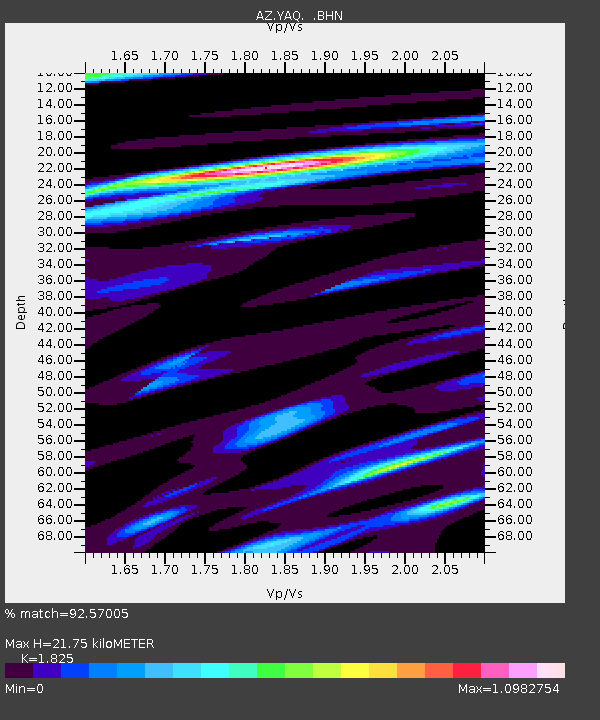
YAQ AZ.YAQ - Earthquake Result Viewer
| Earthquake location: |
Western Brazil |
| Earthquake latitude/longitude: |
-7.6/-71.7 |
| Earthquake time(UTC): |
2003/06/20 (171) 06:19:38 GMT |
| Earthquake Depth: |
558 km |
| Earthquake Magnitude: |
6.4 MB, 7.1 MW, 7.0 MW |
| Earthquake Catalog/Contributor: |
WHDF/NEIC |
|
| Network: |
AZ ANZA Regional Network |
| Station: |
YAQ AZ.YAQ |
| Lat/Lon: |
33.17 N/116.35 W |
| Elevation: |
430 m |
|
| Distance: |
58.7 deg |
| Az: |
316.375 deg |
| Baz: |
125.371 deg |
| Ray Param: |
0.06045284 |
| Estimated Moho Depth: |
21.75 km |
| Estimated Crust Vp/Vs: |
1.83 |
| Assumed Crust Vp: |
6.264 km/s |
| Estimated Crust Vs: |
3.432 km/s |
| Estimated Crust Poisson's Ratio: |
0.29 |
|
| Radial Match: |
92.57005 % |
| Radial Bump: |
400 |
| Transverse Match: |
84.64274 % |
| Transverse Bump: |
400 |
| SOD ConfigId: |
32974 |
| Insert Time: |
2010-03-09 21:26:34.229 +0000 |
| GWidth: |
2.5 |
| Max Bumps: |
400 |
| Tol: |
0.001 |
|

Signal To Noise
| Channel | StoN | STA | LTA |
| AZ:YAQ: :BHN:20030620T06:28:12.300015Z | 7.1595416 | 1.3662434E-6 | 1.9082833E-7 |
| AZ:YAQ: :BHE:20030620T06:28:12.300015Z | 10.841632 | 2.7355177E-6 | 2.5231606E-7 |
| AZ:YAQ: :BHZ:20030620T06:28:12.300015Z | 34.126385 | 6.0835378E-6 | 1.7826494E-7 |
| Arrivals |
| Ps | 3.0 SECOND |
| PpPs | 9.4 SECOND |
| PsPs/PpSs | 12 SECOND |


