You are here: Home > Network List > AZ - ANZA Regional Network Stations List
> Station YAQ AZ.YAQ > Earthquake Result Viewer
YAQ AZ.YAQ - Earthquake Result Viewer
| Earthquake location: |
Southern Bolivia |
| Earthquake latitude/longitude: |
-21.1/-65.6 |
| Earthquake time(UTC): |
2004/03/17 (077) 03:21:07 GMT |
| Earthquake Depth: |
290 km |
| Earthquake Magnitude: |
5.5 MB, 6.1 MW, 6.1 MW |
| Earthquake Catalog/Contributor: |
WHDF/NEIC |
|
| Network: |
AZ ANZA Regional Network |
| Station: |
YAQ AZ.YAQ |
| Lat/Lon: |
33.17 N/116.35 W |
| Elevation: |
430 m |
|
| Distance: |
72.5 deg |
| Az: |
317.069 deg |
| Baz: |
130.696 deg |
| Ray Param: |
0.052778374 |
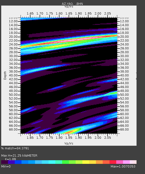
| Estimated Moho Depth: |
21.25 km |
| Estimated Crust Vp/Vs: |
1.89 |
| Assumed Crust Vp: |
6.264 km/s |
| Estimated Crust Vs: |
3.314 km/s |
| Estimated Crust Poisson's Ratio: |
0.31 |
|
| Radial Match: |
84.3791 % |
| Radial Bump: |
393 |
| Transverse Match: |
70.236664 % |
| Transverse Bump: |
386 |
| SOD ConfigId: |
2459 |
| Insert Time: |
2010-03-09 21:26:59.318 +0000 |
| GWidth: |
2.5 |
| Max Bumps: |
400 |
| Tol: |
0.001 |
|

Signal To Noise
| Channel | StoN | STA | LTA |
| AZ:YAQ: :BHN:20040317T03:31:32.500027Z | 2.301289 | 4.242206E-7 | 1.8434042E-7 |
| AZ:YAQ: :BHE:20040317T03:31:32.500027Z | 4.5597878 | 6.4339787E-7 | 1.4110257E-7 |
| AZ:YAQ: :BHZ:20040317T03:31:32.500027Z | 15.843153 | 1.6746153E-6 | 1.0569963E-7 |
| Arrivals |
| Ps | 3.1 SECOND |
| PpPs | 9.5 SECOND |
| PsPs/PpSs | 13 SECOND |


