You are here: Home > Network List > UW - Pacific Northwest Regional Seismic Network Stations List
> Station CVILL Solar Farm Field, Colville, WA, USA > Earthquake Result Viewer
CVILL Solar Farm Field, Colville, WA, USA - Earthquake Result Viewer
| Earthquake location: |
Bonin Islands, Japan Region |
| Earthquake latitude/longitude: |
28.0/142.8 |
| Earthquake time(UTC): |
2022/06/21 (172) 07:14:54 GMT |
| Earthquake Depth: |
10 km |
| Earthquake Magnitude: |
5.9 mww |
| Earthquake Catalog/Contributor: |
NEIC PDE/us |
|
| Network: |
UW Pacific Northwest Regional Seismic Network |
| Station: |
CVILL Solar Farm Field, Colville, WA, USA |
| Lat/Lon: |
48.55 N/117.87 W |
| Elevation: |
581 m |
|
| Distance: |
75.3 deg |
| Az: |
42.67 deg |
| Baz: |
295.525 deg |
| Ray Param: |
0.05175287 |
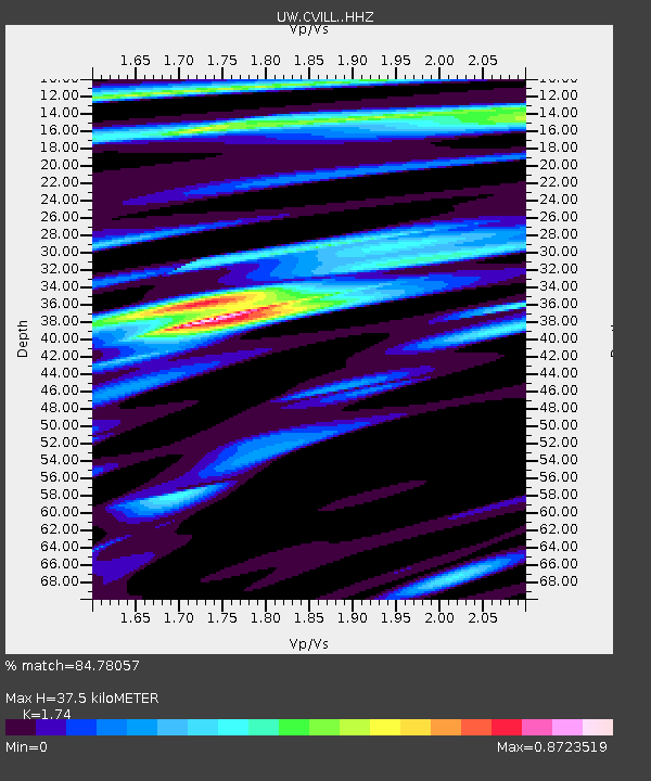
| Estimated Moho Depth: |
37.5 km |
| Estimated Crust Vp/Vs: |
1.74 |
| Assumed Crust Vp: |
6.571 km/s |
| Estimated Crust Vs: |
3.776 km/s |
| Estimated Crust Poisson's Ratio: |
0.25 |
|
| Radial Match: |
84.78057 % |
| Radial Bump: |
400 |
| Transverse Match: |
80.764626 % |
| Transverse Bump: |
400 |
| SOD ConfigId: |
28208852 |
| Insert Time: |
2022-07-05 07:47:00.868 +0000 |
| GWidth: |
2.5 |
| Max Bumps: |
400 |
| Tol: |
0.001 |
|

Signal To Noise
| Channel | StoN | STA | LTA |
| UW:CVILL: :HHZ:20220621T07:26:06.109971Z | 3.3037093 | 2.4818155E-7 | 7.512209E-8 |
| UW:CVILL: :HHN:20220621T07:26:06.109971Z | 1.6108406 | 1.2205088E-7 | 7.576844E-8 |
| UW:CVILL: :HHE:20220621T07:26:06.109971Z | 1.2067549 | 1.1210185E-7 | 9.289529E-8 |
| Arrivals |
| Ps | 4.4 SECOND |
| PpPs | 15 SECOND |
| PsPs/PpSs | 19 SECOND |


