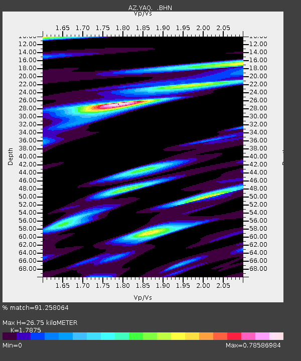
YAQ AZ.YAQ - Earthquake Result Viewer

Earthquake location: South Of Kermadec Islands
Earthquake latitude/longitude: -32.6/-179.4
Earthquake time(UTC): 2005/05/16 (136) 03:54:14 GMT
Earthquake Depth: 34 km
Earthquake Magnitude: 6.2 MB, 6.4 MS, 6.6 MW, 6.6 MW
Earthquake Catalog/Contributor: WHDF/NEIC
Network: AZ ANZA Regional Network
Station: YAQ AZ.YAQ
Lat/Lon: 33.17 N/116.35 W
Elevation: 430 m
Distance: 88.3 deg
Az: 48.388 deg
Baz: 228.808 deg
Ray Param: 0.04264169
Estimated Moho Depth: 26.75 km
Estimated Crust Vp/Vs: 1.79
Assumed Crust Vp: 6.264 km/s
Estimated Crust Vs: 3.504 km/s
Estimated Crust Poisson's Ratio: 0.27
Radial Match: 91.258064 %
Radial Bump: 400
Transverse Match: 86.69939 %
Transverse Bump: 400
SOD ConfigId: 32974
Insert Time: 2010-03-09 21:27:07.828 +0000
GWidth: 2.5
Max Bumps: 400
Tol: 0.001

Signal To Noise

ChannelStoNSTALTA
AZ:YAQ: :BHN:20050516T04:06:31.450017Z1.85253492.931861E-71.5826213E-7
AZ:YAQ: :BHE:20050516T04:06:31.450017Z1.76368943.3574813E-71.9036692E-7
AZ:YAQ: :BHZ:20050516T04:06:31.450017Z15.164811.627452E-61.0731766E-7
Arrivals
Ps3.4 SECOND
PpPs12 SECOND
PsPs/PpSs15 SECOND