You are here: Home > Network List > AZ - ANZA Regional Network Stations List
> Station YAQ AZ.YAQ > Earthquake Result Viewer
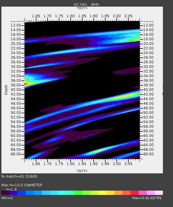
YAQ AZ.YAQ - Earthquake Result Viewer
| Earthquake location: |
Fiji Islands Region |
| Earthquake latitude/longitude: |
-15.3/-178.6 |
| Earthquake time(UTC): |
2005/12/13 (347) 03:16:06 GMT |
| Earthquake Depth: |
10 km |
| Earthquake Magnitude: |
6.1 MB, 6.8 MS, 6.7 MW, 6.7 MW |
| Earthquake Catalog/Contributor: |
WHDF/NEIC |
|
| Network: |
AZ ANZA Regional Network |
| Station: |
YAQ AZ.YAQ |
| Lat/Lon: |
33.17 N/116.35 W |
| Elevation: |
430 m |
|
| Distance: |
76.4 deg |
| Az: |
49.767 deg |
| Baz: |
241.459 deg |
| Ray Param: |
0.051009443 |
| Estimated Moho Depth: |
10.0 km |
| Estimated Crust Vp/Vs: |
1.60 |
| Assumed Crust Vp: |
6.264 km/s |
| Estimated Crust Vs: |
3.915 km/s |
| Estimated Crust Poisson's Ratio: |
0.18 |
|
| Radial Match: |
81.53685 % |
| Radial Bump: |
400 |
| Transverse Match: |
82.87325 % |
| Transverse Bump: |
400 |
| SOD ConfigId: |
2422 |
| Insert Time: |
2010-03-09 21:27:12.589 +0000 |
| GWidth: |
2.5 |
| Max Bumps: |
400 |
| Tol: |
0.001 |
|

Signal To Noise
| Channel | StoN | STA | LTA |
| AZ:YAQ: :BHN:20051213T03:27:24.598994Z | 0.15828587 | 6.200294E-8 | 3.9171493E-7 |
| AZ:YAQ: :BHE:20051213T03:27:24.598994Z | 1.530579 | 2.8426484E-7 | 1.8572374E-7 |
| AZ:YAQ: :BHZ:20051213T03:27:24.598994Z | 3.1033254 | 1.0572262E-6 | 3.4067526E-7 |
| Arrivals |
| Ps | 1.0 SECOND |
| PpPs | 4.0 SECOND |
| PsPs/PpSs | 5.0 SECOND |


