You are here: Home > Network List > AK - Alaska Regional Network Stations List
> Station D20K Etivluk River, AK, USA > Earthquake Result Viewer
D20K Etivluk River, AK, USA - Earthquake Result Viewer
| Earthquake location: |
Southeastern Afghanistan |
| Earthquake latitude/longitude: |
33.1/69.5 |
| Earthquake time(UTC): |
2022/06/21 (172) 20:54:36 GMT |
| Earthquake Depth: |
10 km |
| Earthquake Magnitude: |
5.9 mwb |
| Earthquake Catalog/Contributor: |
NEIC PDE/us |
|
| Network: |
AK Alaska Regional Network |
| Station: |
D20K Etivluk River, AK, USA |
| Lat/Lon: |
68.71 N/156.61 W |
| Elevation: |
577 m |
|
| Distance: |
72.9 deg |
| Az: |
15.983 deg |
| Baz: |
320.727 deg |
| Ray Param: |
0.053343955 |
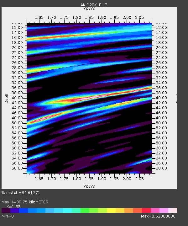
| Estimated Moho Depth: |
39.75 km |
| Estimated Crust Vp/Vs: |
1.85 |
| Assumed Crust Vp: |
6.221 km/s |
| Estimated Crust Vs: |
3.363 km/s |
| Estimated Crust Poisson's Ratio: |
0.29 |
|
| Radial Match: |
84.61771 % |
| Radial Bump: |
400 |
| Transverse Match: |
76.06214 % |
| Transverse Bump: |
400 |
| SOD ConfigId: |
28208852 |
| Insert Time: |
2022-07-05 20:57:17.837 +0000 |
| GWidth: |
2.5 |
| Max Bumps: |
400 |
| Tol: |
0.001 |
|

Signal To Noise
| Channel | StoN | STA | LTA |
| AK:D20K: :BHZ:20220621T21:05:34.260Z | 17.19863 | 2.0305442E-6 | 1.180643E-7 |
| AK:D20K: :BHN:20220621T21:05:34.260Z | 3.6170812 | 2.4495506E-7 | 6.772175E-8 |
| AK:D20K: :BHE:20220621T21:05:34.260Z | 3.0299613 | 4.630496E-7 | 1.5282359E-7 |
| Arrivals |
| Ps | 5.6 SECOND |
| PpPs | 18 SECOND |
| PsPs/PpSs | 23 SECOND |


