You are here: Home > Network List > AK - Alaska Regional Network Stations List
> Station F21K Alatna River, AK, USA > Earthquake Result Viewer
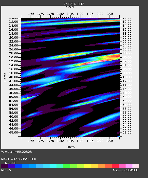
F21K Alatna River, AK, USA - Earthquake Result Viewer
| Earthquake location: |
Southeastern Afghanistan |
| Earthquake latitude/longitude: |
33.1/69.5 |
| Earthquake time(UTC): |
2022/06/21 (172) 20:54:36 GMT |
| Earthquake Depth: |
10 km |
| Earthquake Magnitude: |
5.9 mwb |
| Earthquake Catalog/Contributor: |
NEIC PDE/us |
|
| Network: |
AK Alaska Regional Network |
| Station: |
F21K Alatna River, AK, USA |
| Lat/Lon: |
67.22 N/153.48 W |
| Elevation: |
597 m |
|
| Distance: |
74.8 deg |
| Az: |
15.968 deg |
| Baz: |
323.622 deg |
| Ray Param: |
0.052064173 |
| Estimated Moho Depth: |
32.0 km |
| Estimated Crust Vp/Vs: |
1.98 |
| Assumed Crust Vp: |
6.455 km/s |
| Estimated Crust Vs: |
3.26 km/s |
| Estimated Crust Poisson's Ratio: |
0.33 |
|
| Radial Match: |
90.22525 % |
| Radial Bump: |
400 |
| Transverse Match: |
81.95675 % |
| Transverse Bump: |
400 |
| SOD ConfigId: |
28208852 |
| Insert Time: |
2022-07-05 20:57:41.343 +0000 |
| GWidth: |
2.5 |
| Max Bumps: |
400 |
| Tol: |
0.001 |
|

Signal To Noise
| Channel | StoN | STA | LTA |
| AK:F21K: :BHZ:20220621T21:05:45.400014Z | 37.641953 | 1.5651195E-6 | 4.1579124E-8 |
| AK:F21K: :BHN:20220621T21:05:45.400014Z | 7.8638005 | 3.576037E-7 | 4.5474668E-8 |
| AK:F21K: :BHE:20220621T21:05:45.400014Z | 17.083397 | 4.7296282E-7 | 2.7685525E-8 |
| Arrivals |
| Ps | 5.0 SECOND |
| PpPs | 14 SECOND |
| PsPs/PpSs | 19 SECOND |


