You are here: Home > Network List > AK - Alaska Regional Network Stations List
> Station G17K Kiwalik Mountain, AK, USA > Earthquake Result Viewer
G17K Kiwalik Mountain, AK, USA - Earthquake Result Viewer
| Earthquake location: |
Southeastern Afghanistan |
| Earthquake latitude/longitude: |
33.1/69.5 |
| Earthquake time(UTC): |
2022/06/21 (172) 20:54:36 GMT |
| Earthquake Depth: |
10 km |
| Earthquake Magnitude: |
5.9 mwb |
| Earthquake Catalog/Contributor: |
NEIC PDE/us |
|
| Network: |
AK Alaska Regional Network |
| Station: |
G17K Kiwalik Mountain, AK, USA |
| Lat/Lon: |
65.50 N/160.65 W |
| Elevation: |
338 m |
|
| Distance: |
74.4 deg |
| Az: |
19.422 deg |
| Baz: |
317.978 deg |
| Ray Param: |
0.05240239 |
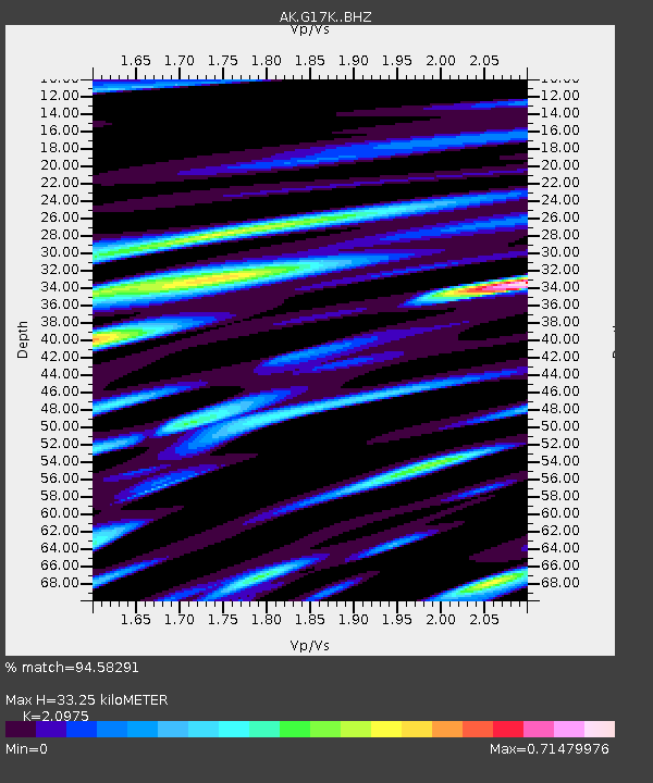
| Estimated Moho Depth: |
33.25 km |
| Estimated Crust Vp/Vs: |
2.10 |
| Assumed Crust Vp: |
6.276 km/s |
| Estimated Crust Vs: |
2.992 km/s |
| Estimated Crust Poisson's Ratio: |
0.35 |
|
| Radial Match: |
94.58291 % |
| Radial Bump: |
400 |
| Transverse Match: |
81.00141 % |
| Transverse Bump: |
400 |
| SOD ConfigId: |
28208852 |
| Insert Time: |
2022-07-05 20:57:48.769 +0000 |
| GWidth: |
2.5 |
| Max Bumps: |
400 |
| Tol: |
0.001 |
|

Signal To Noise
| Channel | StoN | STA | LTA |
| AK:G17K: :BHZ:20220621T21:05:42.559987Z | 16.704695 | 1.4424763E-6 | 8.6351555E-8 |
| AK:G17K: :BHN:20220621T21:05:42.559987Z | 11.11795 | 5.4260823E-7 | 4.88047E-8 |
| AK:G17K: :BHE:20220621T21:05:42.559987Z | 6.412974 | 4.0849076E-7 | 6.3697556E-8 |
| Arrivals |
| Ps | 6.0 SECOND |
| PpPs | 16 SECOND |
| PsPs/PpSs | 22 SECOND |


