You are here: Home > Network List > AK - Alaska Regional Network Stations List
> Station GLI Glacier Island > Earthquake Result Viewer
GLI Glacier Island - Earthquake Result Viewer
| Earthquake location: |
Southeastern Afghanistan |
| Earthquake latitude/longitude: |
33.1/69.5 |
| Earthquake time(UTC): |
2022/06/21 (172) 20:54:36 GMT |
| Earthquake Depth: |
10 km |
| Earthquake Magnitude: |
5.9 mwb |
| Earthquake Catalog/Contributor: |
NEIC PDE/us |
|
| Network: |
AK Alaska Regional Network |
| Station: |
GLI Glacier Island |
| Lat/Lon: |
60.88 N/147.09 W |
| Elevation: |
430 m |
|
| Distance: |
81.7 deg |
| Az: |
17.144 deg |
| Baz: |
329.609 deg |
| Ray Param: |
0.04740791 |
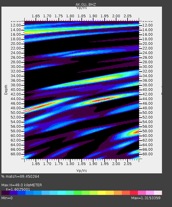
| Estimated Moho Depth: |
49.0 km |
| Estimated Crust Vp/Vs: |
1.60 |
| Assumed Crust Vp: |
6.566 km/s |
| Estimated Crust Vs: |
4.097 km/s |
| Estimated Crust Poisson's Ratio: |
0.18 |
|
| Radial Match: |
89.450264 % |
| Radial Bump: |
400 |
| Transverse Match: |
77.960815 % |
| Transverse Bump: |
400 |
| SOD ConfigId: |
28208852 |
| Insert Time: |
2022-07-05 20:58:03.294 +0000 |
| GWidth: |
2.5 |
| Max Bumps: |
400 |
| Tol: |
0.001 |
|

Signal To Noise
| Channel | StoN | STA | LTA |
| AK:GLI: :BHZ:20220621T21:06:23.207998Z | 23.255985 | 1.3378027E-6 | 5.7525092E-8 |
| AK:GLI: :BHN:20220621T21:06:23.207998Z | 7.1364884 | 3.9269594E-7 | 5.5026494E-8 |
| AK:GLI: :BHE:20220621T21:06:23.207998Z | 7.3470955 | 2.9188905E-7 | 3.9728494E-8 |
| Arrivals |
| Ps | 4.6 SECOND |
| PpPs | 19 SECOND |
| PsPs/PpSs | 23 SECOND |


