You are here: Home > Network List > XM99 - Rio Grande Seismic Transect Stations List
> Station NM33 NewMexico33 > Earthquake Result Viewer
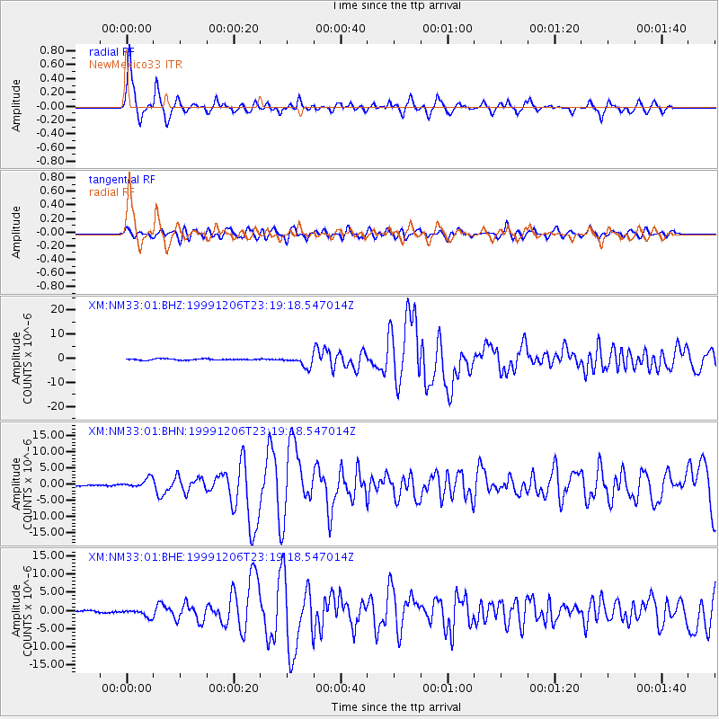
NM33 NewMexico33 - Earthquake Result Viewer

| Earthquake location: |
Kodiak Island Region, Alaska |
| Earthquake latitude/longitude: |
57.4/-154.5 |
| Earthquake time(UTC): |
1999/12/06 (340) 23:12:33 GMT |
| Earthquake Depth: |
66 km |
| Earthquake Magnitude: |
6.8 MB, 7.0 MW, 7.0 ML |
| Earthquake Catalog/Contributor: |
WHDF/NEIC |
|
| Network: |
XM Rio Grande Seismic Transect |
| Station: |
NM33 NewMexico33 |
| Lat/Lon: |
35.11 N/107.42 W |
| Elevation: |
2094 m |
|
| Distance: |
38.4 deg |
| Az: |
104.905 deg |
| Baz: |
320.368 deg |
| Ray Param: |
0.0753889 |
| Estimated Moho Depth: |
42.0 km |
| Estimated Crust Vp/Vs: |
1.82 |
| Assumed Crust Vp: |
6.502 km/s |
| Estimated Crust Vs: |
3.572 km/s |
| Estimated Crust Poisson's Ratio: |
0.28 |
|
| Radial Match: |
92.24228 % |
| Radial Bump: |
371 |
| Transverse Match: |
79.20548 % |
| Transverse Bump: |
400 |
| SOD ConfigId: |
27569 |
| Insert Time: |
2010-02-26 17:30:34.297 +0000 |
| GWidth: |
2.5 |
| Max Bumps: |
400 |
| Tol: |
0.001 |
|
Signal To Noise
| Channel | StoN | STA | LTA |
| XM:NM33:01:BHN:19991206T23:19:18.547014Z | 6.4907084 | 1.4856018E-6 | 2.2888132E-7 |
| XM:NM33:01:BHE:19991206T23:19:18.547014Z | 4.092925 | 1.0626867E-6 | 2.596399E-7 |
| XM:NM33:01:BHZ:19991206T23:19:18.547014Z | 8.241703 | 2.2706997E-6 | 2.7551343E-7 |
| Arrivals |
| Ps | 5.7 SECOND |
| PpPs | 17 SECOND |
| PsPs/PpSs | 23 SECOND |


