You are here: Home > Network List > AK - Alaska Regional Network Stations List
> Station H21K Melozitna River, AK, USA > Earthquake Result Viewer
H21K Melozitna River, AK, USA - Earthquake Result Viewer
| Earthquake location: |
Southeastern Afghanistan |
| Earthquake latitude/longitude: |
33.1/69.5 |
| Earthquake time(UTC): |
2022/06/21 (172) 20:54:36 GMT |
| Earthquake Depth: |
10 km |
| Earthquake Magnitude: |
5.9 mwb |
| Earthquake Catalog/Contributor: |
NEIC PDE/us |
|
| Network: |
AK Alaska Regional Network |
| Station: |
H21K Melozitna River, AK, USA |
| Lat/Lon: |
65.66 N/152.80 W |
| Elevation: |
520 m |
|
| Distance: |
76.3 deg |
| Az: |
16.694 deg |
| Baz: |
324.424 deg |
| Ray Param: |
0.05111001 |
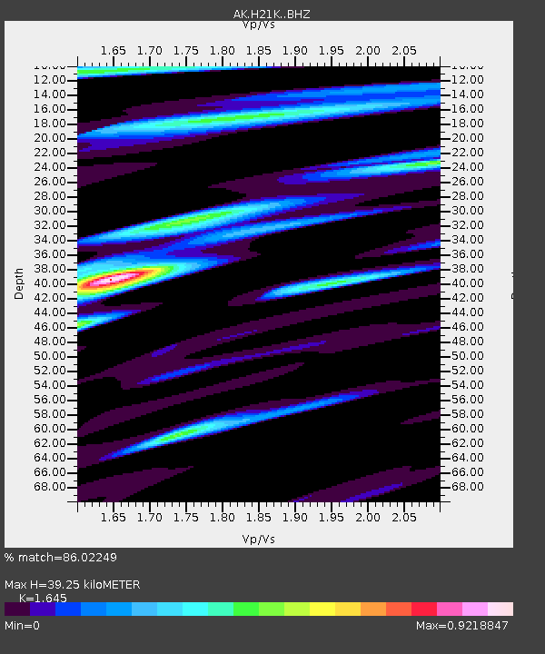
| Estimated Moho Depth: |
39.25 km |
| Estimated Crust Vp/Vs: |
1.64 |
| Assumed Crust Vp: |
6.566 km/s |
| Estimated Crust Vs: |
3.992 km/s |
| Estimated Crust Poisson's Ratio: |
0.21 |
|
| Radial Match: |
86.02249 % |
| Radial Bump: |
400 |
| Transverse Match: |
63.04841 % |
| Transverse Bump: |
400 |
| SOD ConfigId: |
28208852 |
| Insert Time: |
2022-07-05 20:58:13.075 +0000 |
| GWidth: |
2.5 |
| Max Bumps: |
400 |
| Tol: |
0.001 |
|

Signal To Noise
| Channel | StoN | STA | LTA |
| AK:H21K: :BHZ:20220621T21:05:53.580007Z | 32.576656 | 1.4398621E-6 | 4.41992E-8 |
| AK:H21K: :BHN:20220621T21:05:53.580007Z | 8.326121 | 4.737835E-7 | 5.6903264E-8 |
| AK:H21K: :BHE:20220621T21:05:53.580007Z | 5.7382984 | 5.07098E-7 | 8.837079E-8 |
| Arrivals |
| Ps | 4.0 SECOND |
| PpPs | 15 SECOND |
| PsPs/PpSs | 19 SECOND |


